IMAGES TAKEN NEAR TO
Erwood, BUILTH WELLS, LD2 3EZ
Introduction
This page details the photographs taken nearby to LD2 3EZ by members of the Geograph project.
The Geograph project started in 2005 with the aim of publishing, organising and preserving representative images for every square kilometre of Great Britain, Ireland and the Isle of Man.

There are currently over 7.5m images from over14,400 individuals and you can help contribute to the project by visiting https://www.geograph.org.uk
Image Map
Images are licensed for reuse under creativecommons.org/licenses/by-sa/2.0
Notes
- Clicking on the map will re-center to the selected point.
- The higher the marker number, the further away the image location is from the centre of the postcode.
Image Listing (59 Images Found)
Images are licensed for reuse under creativecommons.org/licenses/by-sa/2.0
Image
Details
Distance
1
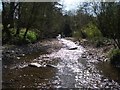
Erwood: stream at its confluence with the Wye
Image: © Keith Salvesen
Taken: 21 Apr 2010
0.02 miles
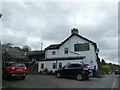
2
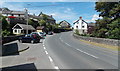
Beware of house, Erwood
The pair of red and yellow signs are intended to warn drivers of the nearness of the house to the A470 roadway. Red Door B&B (formerly Erwood Inn) is in the background. http://www.geograph.org.uk/photo/3545204
Image: © Jaggery
Taken: 7 Jul 2013
0.02 miles
4
The A470 Erwood Bridge, Erwood
This is one of two bridges named Erwood Bridge in or near the village.
This one carries the A470 over Cletwr Brook 100 metres south of its confluence with the River Wye.
A Breconshire County Council plaque on the bridge records its widening in 1937.
Image: © Jaggery
Taken: 7 Jul 2013
0.03 miles
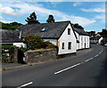
5
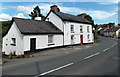
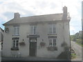
Red Door Bed and Breakfast, Erwood
Viewed across the A470. Located on the west bank of Cletwr Brook, this was until recently Erwood Inn.
Image: © Jaggery
Taken: 7 Jul 2013
0.03 miles
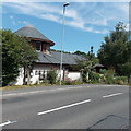
6
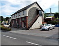
Diamond Jubilee Market Hall, Erwood
Viewed across the A470. A stone tablet on the building shows that the hall was erected by public subscription. The year on the tablet is 1898, the year after the Diamond Jubilee of Queen Victoria's accession to the throne.
Image: © Jaggery
Taken: 7 Jul 2013
0.03 miles
7
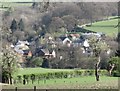
Erwood village
This telephoto is taken from the road running along the old Cambrian Railway line trackbed on the other side of the river Wye
Image: © Flying Stag
Taken: 18 Apr 2014
0.03 miles
9
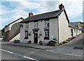
Wheelwright Arms viewed from the west, Erwood
Viewed across the A470, this is the last remaining pub in the village.
The Diamond Jubilee Market Hall http://www.geograph.org.uk/photo/3545122 is on the left.
Image: © Jaggery
Taken: 7 Jul 2013
0.03 miles