IMAGES TAKEN NEAR TO
Llanddewi, LLANDRINDOD WELLS, LD1 6SL
Introduction
This page details the photographs taken nearby to LD1 6SL by members of the Geograph project.
The Geograph project started in 2005 with the aim of publishing, organising and preserving representative images for every square kilometre of Great Britain, Ireland and the Isle of Man.

There are currently over 7.5m images from over14,400 individuals and you can help contribute to the project by visiting https://www.geograph.org.uk
Image Map
Images are licensed for reuse under creativecommons.org/licenses/by-sa/2.0
Notes
- Clicking on the map will re-center to the selected point.
- The higher the marker number, the further away the image location is from the centre of the postcode.
Image Listing (7 Images Found)
Images are licensed for reuse under creativecommons.org/licenses/by-sa/2.0
Image
Details
Distance
1
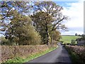
Thin strip of roadside deciduous woodland.
Image: © toby everard
Taken: 26 Oct 2008
0.02 miles
2
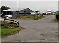
Barnfield Garage near Llanddewi Ystradenni
Premises of M.D.Lewis.
Image: © Jaggery
Taken: 22 Sep 2013
0.03 miles
3
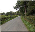
Road NW to Llanddewi Ystradenni
Barnfield Garage http://www.geograph.org.uk/photo/3734029 is behind the camera. Llanddewi Ystradenni is about a kilometre ahead.
Image: © Jaggery
Taken: 22 Sep 2013
0.07 miles
5
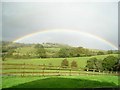
Enfys / Rainbow
Cewch weld golygfa arall o'r ffens chwe mis yn gynharach yn Image], gan Toby Everard.
-----
You can see the other side of the fence six months earlier at Image], by Toby Everard.
Image: © G Williams
Taken: 20 Apr 2009
0.12 miles
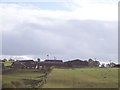
6
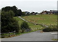
Access road to Caergynant Farm near Llanddewi Ystradenni
Located in upland rural Powys.
Image: © Jaggery
Taken: 22 Sep 2013
0.15 miles
7
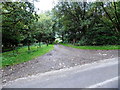
Track into woodland near Llanddewi Ystradenni
Image: © Jaggery
Taken: 22 Sep 2013
0.19 miles