IMAGES TAKEN NEAR TO
Newbridge-on-Wye, LLANDRINDOD WELLS, LD1 6NA
Introduction
This page details the photographs taken nearby to LD1 6NA by members of the Geograph project.
The Geograph project started in 2005 with the aim of publishing, organising and preserving representative images for every square kilometre of Great Britain, Ireland and the Isle of Man.

There are currently over 7.5m images from over14,400 individuals and you can help contribute to the project by visiting https://www.geograph.org.uk
Image Map
Images are licensed for reuse under creativecommons.org/licenses/by-sa/2.0
Notes
- Clicking on the map will re-center to the selected point.
- The higher the marker number, the further away the image location is from the centre of the postcode.
Image Listing (51 Images Found)
Images are licensed for reuse under creativecommons.org/licenses/by-sa/2.0
Image
Details
Distance
1
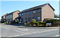
Knapplands, Newbridge-on-Wye
Viewed across the A470. Knapplands is a development of houses and (out of shot) bungalows.
At the far end of Knapplands are bungalows in Meadowlands.
Image: © Jaggery
Taken: 28 Mar 2012
0.14 miles
2

Newbridge on Wye School
The primary school in Newbridge on Wye
Image: © Bill Nicholls
Taken: 28 Apr 2018
0.14 miles
3
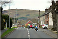
A470 Approaching Newbridge-on-Wye
Newbridge-on-Wye (Welsh: Pontnewydd ar Wy) is a small village which lies, as its name suggests, on the River Wye, just downstream from the market town of Rhayader. The village was historically a stop off point for drovers, who moved livestock from place to place. It proved to be an ideal location for drovers to stop and rest because it afforded a safe crossing-point on the river Wye. This led to a settlement forming, including a large number of pubs.
Image: © David Dixon
Taken: 14 Apr 2016
0.16 miles
4
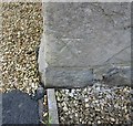
Ordnance Survey Cut Mark
This OS cut mark can be found on the west face of Ridgemount House. It marks a point 174.473m above mean sea level.
Image: © Adrian Dust
Taken: 8 May 2016
0.16 miles
5
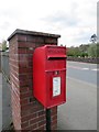
Postbox by the pillar
Postbox beside a fence pillar at the carpark in Newbridge on Wye
Image: © Bill Nicholls
Taken: 28 Apr 2018
0.17 miles
6
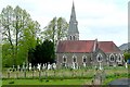
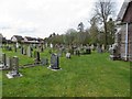
All Saints church
The view is from the south, off the A470, across the graveyard.
Image: © Graham Horn
Taken: 2 May 2009
0.18 miles
7
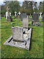
Family Grave
The Pritchard family grave containing the Commonwealth War Grave of Aircraftsman F.T. Pritchard in the churchyard at All Saints', Newbridge on Wye.
Image: © Bill Nicholls
Taken: 28 Apr 2018
0.18 miles
8
Looking eastwards
Looking eastwards in the churchyard in All Saints Newbridge on Wye
Image: © Bill Nicholls
Taken: 28 Apr 2018
0.18 miles
9
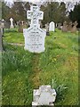
White headstone
A white head & footstone in the churchyard at All Saints', Newbridge on Wye.
Image: © Bill Nicholls
Taken: 28 Apr 2018
0.18 miles
10
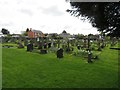
South side churchyard
The churchyard on the south side of St Mary, Newbridge on Wye.
Image: © Bill Nicholls
Taken: 28 Apr 2018
0.18 miles