
IMAGES TAKEN NEAR TO
Beck Foot, KENDAL, LA8 0BW
Introduction
This page details the photographs taken nearby to Beck Foot, LA8 0BW by members of the Geograph project.
The Geograph project started in 2005 with the aim of publishing, organising and preserving representative images for every square kilometre of Great Britain, Ireland and the Isle of Man.

There are currently over 7.5m images from over14,400 individuals and you can help contribute to the project by visiting https://www.geograph.org.uk
Image Map
Images are licensed for reuse under creativecommons.org/licenses/by-sa/2.0
Notes
- Clicking on the map will re-center to the selected point.
- The higher the marker number, the further away the image location is from the centre of the postcode.
Image Listing (107 Images Found)
Images are licensed for reuse under creativecommons.org/licenses/by-sa/2.0
Image
Details
Distance

2
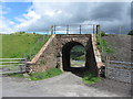
Bridge under the former Ingleton Branch
Image: © Gareth James
Taken: 23 Jul 2015
0.02 miles
3
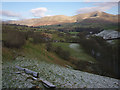
The bridleway at Davy Bank
Heading down to Lowgill. Fell Head rises above the Lune Valley beyond.
Image: © Karl and Ali
Taken: 15 Jan 2012
0.03 miles
4
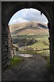
Access to Davy Bank Farm
Access to Davy Bank Farm is via this tunnel under the railway.
Image: © Galatas
Taken: 17 Mar 2008
0.03 miles
5

Milestone beside the B6257 south of Beck Foot
The milestone shows miles to Borrow Bridge and Kirkby Lonsdale and has Milestone Society National ID: WE_BBKL03
Image: © Roger Templeman
Taken: 1 May 2015
0.04 miles
6

Old Milestone by B6257, near small quarry
The Milestone is located by the road on the West of the road. Parish of Firbank (South Lakeland District). Carved stone post, Sedbergh BBKL stone design, erected by the Sedbergh turnpike trust in the 19th Century. An earlier photograph can be found here: https://www.geograph.org.uk/photo/6044219
Inscription reads:-
BB / 3¾ : : KL / 12¾
Grade II listed. List Entry Number: 1312190 https://historicengland.org.uk/listing/the-list/list-entry/1312190
Milestone Society National ID: WE_BBKL03
Image: © Alex Whitlock
Taken: 17 Jan 2018
0.04 miles
7

River Lune
Looking downstream from the bridge. The embankment for the abandoned railway branch line can be seen in the background
Image: © Christopher Atkinson
Taken: 19 Sep 2008
0.04 miles
8
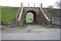
Bridge taking lifted railway over access road to Davy Bank
There is an OS benchmark Image to the right of the open metal gate on the right hand face of the bridge wall
Image: © Roger Templeman
Taken: 1 May 2015
0.04 miles
9

Benchmark on railway bridge at Davy Bank
Ordnance Survey cut mark benchmark described on the Bench Mark Database at http://www.bench-marks.org.uk/bm66543
Image: © Roger Templeman
Taken: 1 May 2015
0.04 miles
10

On a hillside above Davy Bank
From the slopes of this hill there is a good view of the Lowgill Viaduct and the River Lune with the Crook of Lune Bridge over the river. Beyond the M6 and the west coast main railway line curve round into the Lune Gorge.
Image: © Nigel Corby
Taken: 4 Feb 2018
0.14 miles