
IMAGES TAKEN NEAR TO
Burton, CARNFORTH, LA6 1JG
Introduction
This page details the photographs taken nearby to LA6 1JG by members of the Geograph project.
The Geograph project started in 2005 with the aim of publishing, organising and preserving representative images for every square kilometre of Great Britain, Ireland and the Isle of Man.

There are currently over 7.5m images from over14,400 individuals and you can help contribute to the project by visiting https://www.geograph.org.uk
Image Map
Images are licensed for reuse under creativecommons.org/licenses/by-sa/2.0
Notes
- Clicking on the map will re-center to the selected point.
- The higher the marker number, the further away the image location is from the centre of the postcode.
Image Listing (14 Images Found)
Images are licensed for reuse under creativecommons.org/licenses/by-sa/2.0
Image
Details
Distance
1

White Beck
Appearing here as a water feature in someone's garden.
Image: © Karl and Ali
Taken: 4 Mar 2010
0.02 miles
2
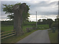
Tree remnant by the track to Coat Green
This large tree (a beech or elm possibly?) may have been cut due to the building of new houses nearby. It caught my notice because of some old graffiti carved into the trunk.
Image: © Karl and Ali
Taken: 31 May 2013
0.04 miles
3
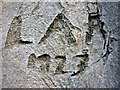
Old graffiti carved on a tree near Coat Green
Spotted on this Image It looks like it might read:
'L A R 1923' or possibly 'L A P 1927'. I wonder what happened to them?
Image: © Karl and Ali
Taken: 31 May 2013
0.04 miles

5

Farmland east of the A6070 at Coat Green
Image: © Eirian Evans
Taken: 21 Sep 2020
0.07 miles

7

This could be White Beck
This small stream certainly flows to White Beck and just clips the corner of this square. It originates a few hundred metres away to the north east from a covered source immediately east of the footpath.
Image: © Karl and Ali
Taken: 4 Mar 2010
0.13 miles
8

Old Boundary Marker by the A6070, west of Coat Green
County Boundary Marker by the A6070, in parish of Burton in Kendal (South Lakeland District), Coatgreen, 100m South of turn to Saltermire Bridge, on grass verge, West side of road.
Inscription reads:-
: LANCASHIRE / (PRIE)ST HUTTON : : COUNTY / BOUNDARY : : WESTMORELAND / DALTON :
Carved benchmark on right face.
Surveyed
Milestone Society National ID: WE_LABK09cb
Image: © Milestone Society
Taken: Unknown
0.14 miles
9

County boundary stone, A6070
Boundary stone by the A6070 between Priest Hutton, Lancashire and Dalton, Westmoreland.
Dalton is now in the parish of Burton in Kendal. Westmorland became part of Cumbria in 1974.
Note the bench mark. See http://www.bench-marks.org.uk/bm36649
Image: © Ian Taylor
Taken: 10 Oct 2010
0.16 miles
