
IMAGES TAKEN NEAR TO
Hornby Bank Bungalows, CARNFORTH, LA6 1EL
Introduction
This page details the photographs taken nearby to Hornby Bank Bungalows, LA6 1EL by members of the Geograph project.
The Geograph project started in 2005 with the aim of publishing, organising and preserving representative images for every square kilometre of Great Britain, Ireland and the Isle of Man.

There are currently over 7.5m images from over14,400 individuals and you can help contribute to the project by visiting https://www.geograph.org.uk
Image Map
Images are licensed for reuse under creativecommons.org/licenses/by-sa/2.0
Notes
- Clicking on the map will re-center to the selected point.
- The higher the marker number, the further away the image location is from the centre of the postcode.
Image Listing (33 Images Found)
Images are licensed for reuse under creativecommons.org/licenses/by-sa/2.0
Image
Details
Distance
1

Congregational chapel, Nether Kellet
A delightful little chapel set back from the village main street behind trees, built in 1869. On a personal note, friends of ours are very involved in the committed Christian witness here. The picture taken on the day of the funeral service for a close friend - a joyful celebration of a modest life with real impact on people near and far. There is more to the life of these little chapels than many would realise.
Image: © Andrew Hill
Taken: 9 Jan 2012
0.05 miles
2

Congregational Church Hall, Nether Kellet
Originally built as a house and barn, the location of the old doorways can be seen.
Image: © Ian Taylor
Taken: 13 Mar 2010
0.05 miles
3

Congregational Church Hall, Nether Kellet
Originally built as a house and barn, this hall was the village school before the current school was built.
Image: © Ian Taylor
Taken: 13 Mar 2010
0.05 miles
4
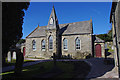
Congregational Church, Nether Kellet
Pevsner states this was built by John Thompson of Lancaster in 1868/9.
Image: © Ian Taylor
Taken: 13 Mar 2010
0.07 miles
5

OS Bench Mark
OS cut bench mark from the 19th century levelling, on corner of house. Somewhat weathered. 260.4 feet above old datum.
Image: © Phil Johnstone
Taken: 10 Sep 2021
0.09 miles
6

Farmland, Nether Kellet
Snow, sheep and an approaching sunset.
Image: © Ian Taylor
Taken: 1 Mar 2015
0.12 miles
7

Limeburners Arms
The Limeburners Arms public house in Nether Kellet.
Image: © Peter McDermott
Taken: 25 Mar 2016
0.13 miles
8

Nether Kellet Village Green
The view is from the north side of the green, looking south-east.
Image: © David Medcalf
Taken: 24 Apr 2005
0.14 miles

10

The Church of St Mark, Nether Kellet, Doorway
Image: © Alexander P Kapp
Taken: 4 Jun 2008
0.15 miles