
IMAGES TAKEN NEAR TO
Leyster Street, MORECAMBE, LA4 5NE
Introduction
This page details the photographs taken nearby to Leyster Street, LA4 5NE by members of the Geograph project.
The Geograph project started in 2005 with the aim of publishing, organising and preserving representative images for every square kilometre of Great Britain, Ireland and the Isle of Man.

There are currently over 7.5m images from over14,400 individuals and you can help contribute to the project by visiting https://www.geograph.org.uk
Image Map
Images are licensed for reuse under creativecommons.org/licenses/by-sa/2.0
Notes
- Clicking on the map will re-center to the selected point.
- The higher the marker number, the further away the image location is from the centre of the postcode.
Image Listing (50 Images Found)
Images are licensed for reuse under creativecommons.org/licenses/by-sa/2.0
Image
Details
Distance
1
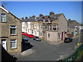
South end of Cross Street, Morecambe
At its junction with Bridge Road, seen from the adjacent railway bridge.
Image: © Richard Vince
Taken: 17 Jun 2017
0.04 miles
2
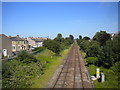
Railway line heading east from Morecambe
Looking towards Bare Lane, Lancaster, and Carnforth from the bridge carrying Lancaster Road across the railway. While this appears to be a double track line, it is in fact two parallel single lines from Bare Lane. The track on the left serves platform 1 at Morecambe station; the one on the right serves platform 2, from which it is possible to reverse onto the line to Heysham Port and Heysham nuclear power station.
Image: © Richard Vince
Taken: 17 Jun 2017
0.05 miles
3
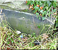
OS Bench Mark
OS cut bench mark from the 20th century levelling, on SW side of York Bridge over railway. 10.61 m above datum. Hidden by vegetation and rather shallowly cut. It replaces an earlier BM on the opposite side of the road.
Image: © Phil Johnstone
Taken: 10 Nov 2021
0.07 miles
4
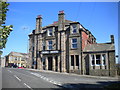
York Hotel, Morecambe
At the top of Out Moss Lane, ironically where it meets Lancaster Road. Seen from Schola Green Lane.
Image: © Richard Vince
Taken: 17 Jun 2017
0.07 miles
5
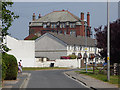
Out Moss Lane and the York Hotel
The hotel Image is a prominent local landmark, see here from the former railway level crossing nearby.
Image: © Stephen Craven
Taken: 9 Jun 2018
0.07 miles
6

1st Stop DIY, Euston Road, Morecambe (1)
In what appears to be a former spaceport, but is more likely to be a former cinema.
Image: © Richard Vince
Taken: 17 Jun 2017
0.10 miles
7

1st Stop DIY, Euston Road, Morecambe (2)
In what appears to be a former spaceport, but is more likely to be a former cinema.
Image: © Richard Vince
Taken: 17 Jun 2017
0.12 miles
8

OS Bench Mark
OS cut bench mark from the 19th century levelling, on north face of No.2 Primrose Street. 24.7 feet above old datum. Rather weathered.
Image: © Phil Johnstone
Taken: 4 Nov 2021
0.12 miles
9

OS Bench Mark
OS cut bench mark from the 20th century levelling, on NW corner of former cinema, now a DIY store. 7.916 m above datum. This replaces an earlier bench mark on the opposite corner of the building.
Image: © Phil Johnstone
Taken: 4 Nov 2021
0.13 miles
10

1st Stop DIY, Morecambe
Ex-Odeon cinema on Lancaster Road/Euston Road, now a low-rent DIY store.
Image: © Dave Martin
Taken: 19 Apr 2006
0.13 miles