
IMAGES TAKEN NEAR TO
Burford Drive, MORECAMBE, LA3 2EZ
Introduction
This page details the photographs taken nearby to Burford Drive, LA3 2EZ by members of the Geograph project.
The Geograph project started in 2005 with the aim of publishing, organising and preserving representative images for every square kilometre of Great Britain, Ireland and the Isle of Man.

There are currently over 7.5m images from over14,400 individuals and you can help contribute to the project by visiting https://www.geograph.org.uk
Image Map
Images are licensed for reuse under creativecommons.org/licenses/by-sa/2.0
Notes
- Clicking on the map will re-center to the selected point.
- The higher the marker number, the further away the image location is from the centre of the postcode.
Image Listing (11 Images Found)
Images are licensed for reuse under creativecommons.org/licenses/by-sa/2.0
Image
Details
Distance


10
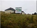
Higher Heysham
Top is a reservoir which I had a look at with Martin Richardson from Seymour Grove and Fell View. fellsidehomes.co.uk are due to build seven four bedroom homes here so may come back to view from an upstairs window of the show home.
Name: Higher Heysham
Hill number: 108385
Height: 42m / 138ft
Area: 36: Lancashire, Cheshire & the Southern Pennines
Class: 0
Grid ref: SD418614 (est)
Drop: 39m
Col: 3m
The application site is located at the eastern end of Seymour Grove, Heysham, accessed directly off Heysham Road (A589). The site lies on the crest of a ridge running approximately north-south across the site and continuing northwards. The site is currently occupied by a redundant, semisubmerged covered reservoir. The reservoir occupies approximately 30% of the site in a central location. Above ground the whole of the site in made over to grass with the exception of two small single storey buildings used as a pumping station and electricity sub-station respectively. The reservoir is built partially above the natural ground level and has a short steep embankment raising the ground level between 1.0m and 2.2m above the surrounding ground.
Image: © Rude Health
Taken: 8 Dec 2013
0.19 miles