
IMAGES TAKEN NEAR TO
Devonshire Road, MORECAMBE, LA3 1SF
Introduction
This page details the photographs taken nearby to Devonshire Road, LA3 1SF by members of the Geograph project.
The Geograph project started in 2005 with the aim of publishing, organising and preserving representative images for every square kilometre of Great Britain, Ireland and the Isle of Man.

There are currently over 7.5m images from over14,400 individuals and you can help contribute to the project by visiting https://www.geograph.org.uk
Image Map
Images are licensed for reuse under creativecommons.org/licenses/by-sa/2.0
Notes
- Clicking on the map will re-center to the selected point.
- The higher the marker number, the further away the image location is from the centre of the postcode.
Image Listing (136 Images Found)
Images are licensed for reuse under creativecommons.org/licenses/by-sa/2.0
Image
Details
Distance

2

The Gerry Forsberg Memorial, Morecambe
A tribute to a remarkable athlete and seaman
Image: © David Medcalf
Taken: 26 Jul 2005
0.02 miles
3

Regent Road, Co-Op Store
Now closed Dame Thora Hird used to work here
Image: © Robert Wade
Taken: 2 Apr 2009
0.04 miles
4

Turf zone DevonshireSq
Off Devonshire Road, Morecambe.
Image: © Ian S
Taken: 27 May 2023
0.06 miles
5
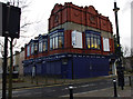
Devonshire Hall, Morecambe
Built as a music hall in 1899. See http://www.arthurlloyd.co.uk/Morecambe.htm
Fairly recently it was occupied by shops on the ground floor and a snooker club upstairs.
Now known as The Hothouse, and occupied by More Music, a community music and education charity. See http://www.moremusic.org.uk/
Image: © Ian Taylor
Taken: 18 Nov 2012
0.07 miles


9

OS Bench Mark
OS cut bench mark from the 20th century levelling, on garden wall of No.,163 Westminster Road. 20.15 feet above datum. Visible despite paint.
Image: © Phil Johnstone
Taken: 23 Nov 2021
0.09 miles
10

OS Bench Mark
OS cut bench mark from the 20th century levelling, at entrance to Park Hotel car park. 26.83 feet above old datum. Obscured by peeling paint.
Image: © Phil Johnstone
Taken: 23 Nov 2021
0.11 miles