
IMAGES TAKEN NEAR TO
Clapham, LANCASTER, LA2 8HW
Introduction
This page details the photographs taken nearby to LA2 8HW by members of the Geograph project.
The Geograph project started in 2005 with the aim of publishing, organising and preserving representative images for every square kilometre of Great Britain, Ireland and the Isle of Man.

There are currently over 7.5m images from over14,400 individuals and you can help contribute to the project by visiting https://www.geograph.org.uk
Image Map
Images are licensed for reuse under creativecommons.org/licenses/by-sa/2.0
Notes
- Clicking on the map will re-center to the selected point.
- The higher the marker number, the further away the image location is from the centre of the postcode.
Image Listing (5 Images Found)
Images are licensed for reuse under creativecommons.org/licenses/by-sa/2.0
Image
Details
Distance
1
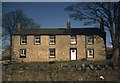
Greenclose NPC HQ in 1976
The Northern Pennine Club first started making Greenclose fit for use at the end of 1955, and signed a fifteen year lease on March 24th 1956. It was eventually purchased (for £850 in cash - in a suitcase!) in 1967. Many improvements had been made before this photo was taken in summer of 1976, and many more have been made since (cf. Image])
Image: © Andy Waddington
Taken: Unknown
0.07 miles
4
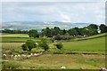
Disused railway bridge
Bridge immediately West of that labelled 'Green Close Bridge' on the OS map.
Image: © Mike Green
Taken: 12 Jul 2009
0.13 miles
5
Sheep near Green Close Bridge
Enjoying the sun of a fine July evening. Ingleborough beyond.
Image: © Karl and Ali
Taken: 24 Jul 2011
0.15 miles