IMAGES TAKEN NEAR TO
Hall Close, LANCASTER, LA2 8BX
Introduction
This page details the photographs taken nearby to Hall Close, LA2 8BX by members of the Geograph project.
The Geograph project started in 2005 with the aim of publishing, organising and preserving representative images for every square kilometre of Great Britain, Ireland and the Isle of Man.

There are currently over 7.5m images from over14,400 individuals and you can help contribute to the project by visiting https://www.geograph.org.uk
Image Map
Images are licensed for reuse under creativecommons.org/licenses/by-sa/2.0
Notes
- Clicking on the map will re-center to the selected point.
- The higher the marker number, the further away the image location is from the centre of the postcode.
Image Listing (76 Images Found)
Images are licensed for reuse under creativecommons.org/licenses/by-sa/2.0
Image
Details
Distance
2
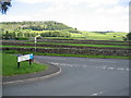
View to Oxenber Wood
The view from the end of Townhead Lane across the fields towards the prominent Oxenber Wood. Oxenber Wood is an SSSI and has areas of limestone pavement as well as trees. Parts of the wood have Common Rights for grazing stock, and Austwick Parishioners may collect sticks and stones. http://www.english-nature.org.uk/citation/citation_photo/1002955.pdf
Image: © John S Turner
Taken: 21 Jul 2008
0.07 miles
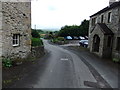
4
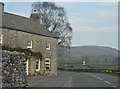
A seat with a view in Austwick
This seat is on the corner of Townhead Lane and the road from Austwick to Helwith Bridge. The expansive view in the opposite direction is excellent, especially on a sunny day - Image and Image
Image: © John S Turner
Taken: 21 Jul 2008
0.08 miles
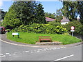
5
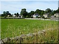
Austwick
Small Yorkshire village on the edge of the Yorkshire Dales.
Image: © philandju
Taken: 17 Aug 2015
0.08 miles
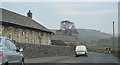
8
View towards Moughton Nab
Looking along the Austwick Beck valley in the direction of Moughton Nab.
Image: © John S Turner
Taken: 21 Jul 2008
0.08 miles
9
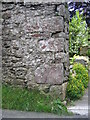
Bench mark in Townhead Lane
This bench mark seems to be on a wall that has stood for centuries, but it is not recorded on the O.S. database, and I have not found it shown on any map. See also Image
Image: © John S Turner
Taken: 21 Jul 2008
0.08 miles
10
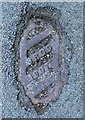
Sewer vent grate dated 1907
SRDC stands for Settle Rural District Council. The grate probably also served as a rodding eye, with a curved pipe down to the sewer. 1907 was the year that the village's sewerage system was constructed, in conjunction with an isolation hospital that opened in the same year. This was in the stone buildings now used for the Dalesbridge Outdoor Centre (see http://www.northcravenheritage.org.uk/nchtjournal/Journals/1996/J96A8.html).
Image: © Humphrey Bolton
Taken: 4 Aug 2014
0.08 miles