
IMAGES TAKEN NEAR TO
Millholme Drive, LANCASTER, LA2 7NE
Introduction
This page details the photographs taken nearby to Millholme Drive, LA2 7NE by members of the Geograph project.
The Geograph project started in 2005 with the aim of publishing, organising and preserving representative images for every square kilometre of Great Britain, Ireland and the Isle of Man.

There are currently over 7.5m images from over14,400 individuals and you can help contribute to the project by visiting https://www.geograph.org.uk
Image Map
Images are licensed for reuse under creativecommons.org/licenses/by-sa/2.0
Notes
- Clicking on the map will re-center to the selected point.
- The higher the marker number, the further away the image location is from the centre of the postcode.
Image Listing (58 Images Found)
Images are licensed for reuse under creativecommons.org/licenses/by-sa/2.0
Image
Details
Distance
1
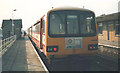
High Bentham Station
The photo was taken when the Pacers were new to the line but they are (I think) still running it 20 years on.
Image: © Stephen Craven
Taken: 17 Apr 1987
0.08 miles
2

Station Road, High Bentham
Looking south along Station Road with the entrance to St Margaret's church on the left.
Image: © John S Turner
Taken: 31 Aug 2011
0.11 miles
3

Beck running south towards Bentham Bridge
A tributary of the River Wenning.
Image: © Christine Johnstone
Taken: 22 Feb 2018
0.11 miles
4

Rivet bench mark on culvert over Lairgill Beck
This rivet bench mark is on the north east corner of the bridge/culvert over Lairgill Beck alongside Station Road, High Bentham. The bridge provides access to St Margaret's Church. See also Image
Image: © John S Turner
Taken: 31 Aug 2011
0.12 miles
5

Bridge over Lairgill Beck and a rivet bench mark
This bridge/culvert over Lairgill Beck provides access to St Margaret's church. The rivet bench mark is on the north east corner - Image
Image: © John S Turner
Taken: 31 Aug 2011
0.12 miles
6

Bentham Station
The residents of the small town of High Bentham are indeed fortunate to have access to the railway network, with a thriving station on the Leeds/Lancaster Line.
Image: © Chris Heaton
Taken: 18 Sep 2007
0.13 miles
7
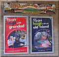
Posters & sign, Bentham station
Advertising posters and sign on the eastbound platform.
The old style sign commemorates 150 years (1850 - 2000) of the Leeds to Morecambe line, via Lunesdale, Wenningdale, Ribblesdale & Airedale.
Image: © Ian Taylor
Taken: 22 May 2010
0.13 miles
8

Bentham Station
View westward, towards Lancaster, Morecambe/Heysham Harbour; ex-Midland Hellifield - Clapham - Wennington - Carnforth/Lancaster - Morecambe/Heysham secondary main line. (On 3/1/66, the direct line Wennington - Lancaster - Morecambe was closed; trains now reach Morecambe and Heysham via Carnforth).
Image: © Ben Brooksbank
Taken: 22 Sep 1962
0.13 miles
9

Bentham station
Looking towards Carnforth from the footbridge.
See Ben Brooksbank's photo Image for a similar view in 1962.
The station buildings and George Angus (now Kidde) factory (see Image ) remain, but the sidings on both sides of the line have gone.
Image: © Ian Taylor
Taken: 22 May 2010
0.14 miles
10

Bentham station
Looking towards Skipton from the westbound platform. This line (Carnforth - Settle Junction) must be one of the quietest sections of double-track railway in the country. There are 5 passenger trains per day in each direction, and no regular freight trains as far as I am aware.
Image: © Ian Taylor
Taken: 22 May 2010
0.14 miles