
IMAGES TAKEN NEAR TO
Church Street, AMBLESIDE, LA22 0BU
Introduction
This page details the photographs taken nearby to Church Street, LA22 0BU by members of the Geograph project.
The Geograph project started in 2005 with the aim of publishing, organising and preserving representative images for every square kilometre of Great Britain, Ireland and the Isle of Man.

There are currently over 7.5m images from over14,400 individuals and you can help contribute to the project by visiting https://www.geograph.org.uk
Image Map
Images are licensed for reuse under creativecommons.org/licenses/by-sa/2.0
Notes
- Clicking on the map will re-center to the selected point.
- The higher the marker number, the further away the image location is from the centre of the postcode.
Image Listing (640 Images Found)
Images are licensed for reuse under creativecommons.org/licenses/by-sa/2.0
Image
Details
Distance
1
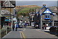
Church Street, Ambleside
Caught during a fleeting gap in the traffic.
Image: © David Martin
Taken: 14 Apr 2015
0.01 miles
2

Back alley, Ambleside
Not one of the areas visited much by the thousands of tourists.
Image: © michael ely
Taken: 27 Mar 2011
0.01 miles
3

Former Police Station, Ambleside
It is located along Church Street
See close-up of plaque here Image]
Image: © Kenneth Allen
Taken: 18 Apr 2013
0.01 miles
4
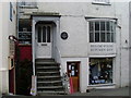
Shop in Church Street, Ambleside
This photo is taken in Church Street in the centre of Ambleside, its postcode being LA22 0BU. The plaque referring to William Wordsworth can be seen adjacent to the upper door, NY3704 refers.
Image: © David Hillas
Taken: 5 Mar 2011
0.02 miles
5
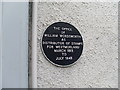
Plaque in Church Street, Ambleside
This plaque can be seen above a shop in Church Street and says the following " The office of William Wordsworth as Distributor of Stamps for Westmorland March 1913 to July 1843". He was living at Rydal Mount nearby, NY3606 refers.
Image: © David Hillas
Taken: 5 Mar 2011
0.02 miles

7
![Ambleside houses [27]](https://s0.geograph.org.uk/geophotos/06/23/18/6231840_99d0a04e_120x120.jpg)
Ambleside houses [27]
Numbers 2 to 11 Church Street are a terrace of late 17th century cottages stepped down the hill. Listed, grade II, with details at: https://historicengland.org.uk/listing/the-list/list-entry/1245006
Image: © Michael Dibb
Taken: 23 Jun 2019
0.02 miles
8

Church Street, Ambleside
Looking down Church Street, Ambleside. On the right of the image is the Priest Hole, one of a large number of pubs in the town.
Image: © Graham Robson
Taken: 7 Nov 2011
0.02 miles
9
![Ambleside buildings [20]](https://s3.geograph.org.uk/geophotos/06/23/08/6230823_86ea0eee_120x120.jpg)
Ambleside buildings [20]
Occupied by The Priest Hole Restaurant, Stoneage and Oxfam, this probably 18th century building is listed, grade II, with details at: https://historicengland.org.uk/listing/the-list/list-entry/1244794
Image: © Michael Dibb
Taken: 23 Jun 2019
0.02 miles
