
IMAGES TAKEN NEAR TO
The Square, BROUGHTON-IN-FURNESS, LA20 6JA
Introduction
This page details the photographs taken nearby to The Square, LA20 6JA by members of the Geograph project.
The Geograph project started in 2005 with the aim of publishing, organising and preserving representative images for every square kilometre of Great Britain, Ireland and the Isle of Man.

There are currently over 7.5m images from over14,400 individuals and you can help contribute to the project by visiting https://www.geograph.org.uk
Image Map
Images are licensed for reuse under creativecommons.org/licenses/by-sa/2.0
Notes
- Clicking on the map will re-center to the selected point.
- The higher the marker number, the further away the image location is from the centre of the postcode.
Image Listing (104 Images Found)
Images are licensed for reuse under creativecommons.org/licenses/by-sa/2.0
Image
Details
Distance
1

Weather vane, Broughton in Furness
Weather vanes have always been more than just a wind direction device. Created by skilled craftsman, there is true artistic expression in the varied designs. Initially wood vanes were carved by carpenters or furniture makers, and iron, copper and tin ones were forged by the local blacksmith or tinsmith. In the 19th century weather vanes started to be mass-produced from moulds.
Image: © Maigheach-gheal
Taken: 25 Mar 2010
0.02 miles
2

New Street in Broughton-in-Furness
Looking north-westward.
Image: © Peter Wood
Taken: 31 Oct 2018
0.03 miles
3

Ordnance Survey Rivet
This OS rivet can be found on the monument. It marks a point 21.620m above mean sea level.
Image: © Adrian Dust
Taken: 8 Jun 2016
0.03 miles
4

Sign for the Manor Inn
The sign is attached to the front wall of the inn.
Image: © Maigheach-gheal
Taken: 23 Mar 2010
0.03 miles
5

The Square Broughton in Furness
Small market town with more pubs than shops.
Image: © Steve Fareham
Taken: 28 May 2010
0.03 miles
6

The King George III obelisk, Broughton-in-Furness
The obelisk in the square was erected to commemorate the jubilee of King George III in 1810. There is a set of stocks beside it and a couple of slate 'fish slabs' (makeshift signs ask you not to sit on them).
Image: © Karl and Ali
Taken: 14 Sep 2013
0.03 miles
7

Obelisk in the square at Broughton in Furness
Image: © David Martin
Taken: 18 Apr 2015
0.03 miles
8

Obelisk in the square in Broughton in Furness
Erected in 1810 to commemorate the 50th year of the reign of King George III.
Image: © Rod Allday
Taken: 4 Apr 2015
0.03 miles
9
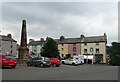
King George III obelisk, Broughton-in-Furness
Erected to commemorate the jubilee of King George III in 1810.
Image: © JThomas
Taken: 3 Jul 2021
0.03 miles
10
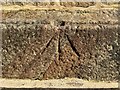
Benchmark, Broughton in Furness, Obelisk
Detail of the Ordnance Survey rivet benchmark with cut mark arrow on the northwest face of the plinth of Broughton in Furness Obelisk.
The benchmark marks a height of 21.6195m above mean sea level (Ordnance Datum Newlyn) last levelled and verified in 1969 (location photograph Image).
Image: © Adrian Taylor
Taken: 23 Mar 2022
0.03 miles