
IMAGES TAKEN NEAR TO
William Priestley Park, LANCASTER, LA1 5WD
Introduction
This page details the photographs taken nearby to William Priestley Park, LA1 5WD by members of the Geograph project.
The Geograph project started in 2005 with the aim of publishing, organising and preserving representative images for every square kilometre of Great Britain, Ireland and the Isle of Man.

There are currently over 7.5m images from over14,400 individuals and you can help contribute to the project by visiting https://www.geograph.org.uk
Image Map
Images are licensed for reuse under creativecommons.org/licenses/by-sa/2.0
Notes
- Clicking on the map will re-center to the selected point.
- The higher the marker number, the further away the image location is from the centre of the postcode.
Image Listing (156 Images Found)
Images are licensed for reuse under creativecommons.org/licenses/by-sa/2.0
Image
Details
Distance
1

"Resurrection"
Part of a building wall on New Quay Road
Image: © Alexander P Kapp
Taken: 29 Jan 2008
0.03 miles
2

Face of a derelict building on New Quay Road
Image: © Alexander P Kapp
Taken: 29 Jan 2008
0.03 miles
3

Luneside East Regeneration
The land in the foreground has been cleared and levelled prior to redevelopment. The building on the left is the St George's Works, on the right is the pumphouse.
Image: © Ian Taylor
Taken: 23 Mar 2014
0.04 miles
4
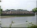
New housing development, St George's Walk
Viewed from across the river. See Image for the derelict site before development started, and Image for one of the old buildings that was demolished.
Image: © Stephen Craven
Taken: 9 Jun 2018
0.04 miles
5

Luneside East Regeneration Area
Former dockland in need of a new use. The Priory Church is visible on the skyline.
Image: © Bill Boaden
Taken: 3 Nov 2012
0.04 miles
6

Booth Gardens
Redevelopment of the old Luneside East industrial site continues. In the foreground, new town houses have been completed. In the background, one of four new student accommodation blocks is under construction.
Image: © Ian Taylor
Taken: 25 Feb 2020
0.04 miles
7
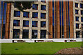
Luneside student accommodation
Four new student accommodation blocks have been built on the old Luneside East industrial site.
The benches in the foreground incorporate datestones rescued from the demolition of the former gasworks building. (see Image)
Image: © Ian Taylor
Taken: 25 Apr 2021
0.05 miles
8

Luneside East Regeneration
Redevelopment of the old Luneside East industrial site continues.
Four new student accommodation blocks are being built (3 are visible here).
The old pumphouse is the only remaining St George's Works building (centre right). (Also see Image) This will renovated to provide a "central facilities hub".
New town houses have been built on the extreme right.
Two of the arches on the south side of Carlisle Bridge, which carries the West Coast Main Line over the River Lune, are in the background.
Image: © Ian Taylor
Taken: 6 Sep 2019
0.05 miles
9

Luneside East Regeneration
The first stage of redevelopment of the old Luneside East industrial site is in progress - the demolition of unfit buildings and clearance of contaminated land.
The eastern (far) end of the Lune Mills building has been demolished. This building was damaged by fire in May 2012. (Compare with Alexander P Kapp's 2008 photo Image)
Image: © Ian Taylor
Taken: 19 Apr 2013
0.05 miles
10
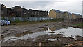
Luneside East Regeneration
Redevelopment of the old Luneside East industrial site is in progress. On the left, the remainder of the St George's Works building is being demolished. New apartment blocks have been built on the right. (Compare with Image & Image)
Image: © Ian Taylor
Taken: 10 Nov 2018
0.05 miles