
IMAGES TAKEN NEAR TO
Ashton Road, LANCASTER, LA1 4RS
Introduction
This page details the photographs taken nearby to Ashton Road, LA1 4RS by members of the Geograph project.
The Geograph project started in 2005 with the aim of publishing, organising and preserving representative images for every square kilometre of Great Britain, Ireland and the Isle of Man.

There are currently over 7.5m images from over14,400 individuals and you can help contribute to the project by visiting https://www.geograph.org.uk
Image Map
Images are licensed for reuse under creativecommons.org/licenses/by-sa/2.0
Notes
- Clicking on the map will re-center to the selected point.
- The higher the marker number, the further away the image location is from the centre of the postcode.
Image Listing (47 Images Found)
Images are licensed for reuse under creativecommons.org/licenses/by-sa/2.0
Image
Details
Distance
1
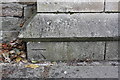
Benchmark on gatepost at entrance to Ripley St Thomas School
Ordnance Survey cut mark benchmark described on the Bench Mark Database at http://www.bench-marks.org.uk/bm77008
Image: © Roger Templeman
Taken: 13 Jul 2016
0.07 miles
2
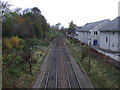
Railway heading into Lancaster
West Coast Main Line.
Image: © JThomas
Taken: 16 Nov 2013
0.07 miles
3
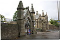
Entrance to Ripley St Thomas School from Ashton Road
There is an OS benchmark Image on the base stone of the nearest gatepost
Image: © Roger Templeman
Taken: 13 Jul 2016
0.08 miles
4
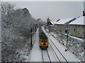
West Coast Rail Line
From the bridge at Ripley School. The school buildings in shot on the right. A 50 minute delay for trains this morning into Lancaster due to frozen points.
Image: © Michael Graham
Taken: 22 Dec 2009
0.09 miles
5
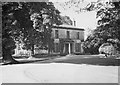
Springfield Hall, Lancaster
The house was built in 1782. For some information on its history see https://www.lancasterguardian.co.uk/lifestyle/sights-past-lancaster-hall-and-park-650070. The building was demolished at some time after this photograph was taken to allow expansion of the Lancashire Royal Infirmary.
Photograph by Geoffrey William Sutcliffe (1907-2004), the contributor's father
Image: © Geoffrey William Sutcliffe
Taken: Unknown
0.09 miles
6
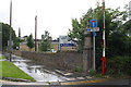
Cycle path/footpath off Ashton Road
There is an OS benchmark Image on the inside face of the gatepost
Image: © Roger Templeman
Taken: 13 Jul 2016
0.10 miles
7
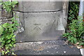
Benchmark on gatepost on NW side of Ashton Road
Ordnance Survey cut mark benchmark described on the Bench Mark Database at http://www.bench-marks.org.uk/bm77009
Image: © Roger Templeman
Taken: 13 Jul 2016
0.11 miles
8

The summer house, Springfield Hall, Lancaster
The scouts were from 3rd Altrincham Scout Group, and were en route by bicycle to Lowes Water in the Lake District to assist with the war effort, by cutting pit props. The owner of Springfield Hall allowed them to 'camp' for the night in the summer house.
Photograph by Geoffrey William Sutcliffe (1907-2004), the contributor's father
Image: © Geoffrey William Sutcliffe
Taken: Unknown
0.14 miles
9
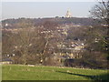
From Ripley Heights
Looking over Greaves and Bowerham towards Williamson's Park
Image: © Michael Graham
Taken: 13 Feb 2008
0.14 miles
10

Sheep, Ripley Heights
Sheep grazing within half a mile of Lancaster City Centre. Castle, Town Hall and Cathedral all in shot
Image: © Michael Graham
Taken: 13 Feb 2008
0.15 miles