IMAGES TAKEN NEAR TO
Church Street, BARROW-IN-FURNESS, LA14 2HY
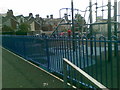
Introduction
This page details the photographs taken nearby to Church Street, LA14 2HY by members of the Geograph project.
The Geograph project started in 2005 with the aim of publishing, organising and preserving representative images for every square kilometre of Great Britain, Ireland and the Isle of Man.

There are currently over 7.5m images from over14,400 individuals and you can help contribute to the project by visiting https://www.geograph.org.uk
Image Map
Images are licensed for reuse under creativecommons.org/licenses/by-sa/2.0
Notes
- Clicking on the map will re-center to the selected point.
- The higher the marker number, the further away the image location is from the centre of the postcode.
Image Listing (91 Images Found)
Images are licensed for reuse under creativecommons.org/licenses/by-sa/2.0
Image
Details
Distance
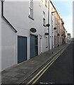
1
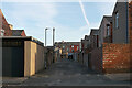
The alley between Church Street and Brown Street, Barrow-In-Furness
Image: © habiloid
Taken: 29 May 2023
0.02 miles
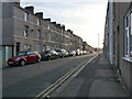
2
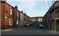
Brown Street seen from Albert Street, Barrow-In-Furness
Image: © habiloid
Taken: 29 May 2023
0.03 miles
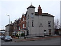
3
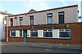
Costello's Bar, Ramsden Street, Barrow-In-Furness
Image: © habiloid
Taken: 29 May 2023
0.04 miles
8
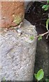
Ordnance Survey Rivet
This slightly damaged OS rivet can be found on the Archway SW side of the road. It marks a point 7.954m above mean sea level.
Image: © Adrian Dust
Taken: 15 Oct 2019
0.07 miles