
IMAGES TAKEN NEAR TO
Borrowdale Road, LANCASTER, LA1 3PW
Introduction
This page details the photographs taken nearby to Borrowdale Road, LA1 3PW by members of the Geograph project.
The Geograph project started in 2005 with the aim of publishing, organising and preserving representative images for every square kilometre of Great Britain, Ireland and the Isle of Man.

There are currently over 7.5m images from over14,400 individuals and you can help contribute to the project by visiting https://www.geograph.org.uk
Image Map
Images are licensed for reuse under creativecommons.org/licenses/by-sa/2.0
Notes
- Clicking on the map will re-center to the selected point.
- The higher the marker number, the further away the image location is from the centre of the postcode.
Image Listing (101 Images Found)
Images are licensed for reuse under creativecommons.org/licenses/by-sa/2.0
Image
Details
Distance
1

OS Bench Mark
OS cut bench mark from the 19th century levelling, on house at corner of Wolseley Street and Ullswater Road. 80.9 feet above old datum. Now very weathered. This bench mark is shown on the 1893, 1936 and 1939 25" maps, but not the 1913 map.
Image: © Phil Johnstone
Taken: 20 Oct 2021
0.02 miles

3
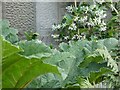
OS Bench Mark
OS cut bench mark from the 19th century levelling, on a house at the corner of Borrowdale Road and Ullswater Road.
Image: © Phil Johnstone
Taken: 1 Aug 2021
0.04 miles
4

Lancaster Canal
From Bulk approaching the Ridge.
Image: © Michael Graham
Taken: 10 Dec 2009
0.05 miles

6
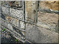
OS Bench Mark
OS cut bench mark from the 19th century levelling, on the corner of a house on Mill Street. Somewhat weathered. 86.2 feet above old datum. Strangely, this bench mark appears on the 1890, 1931 and 1938 editions of the 25-inch maps, but not the 1910 edition.
Image: © Phil Johnstone
Taken: 19 Aug 2021
0.06 miles
7
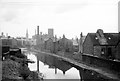
Lancaster Canal ? 1965
Looking south from Ridge Lane Bridge. The cotton mills have since disappeared from the landscape.
Update: My thanks to Ian Taylor for providing this 21st century view from the same location https://www.geograph.org.uk/photo/6517079
Image: © Alan Murray-Rust
Taken: Unknown
0.07 miles
8

Houses along the Lancaster Canal in Lancaster
Image: © Mat Fascione
Taken: 17 Sep 2018
0.08 miles
9
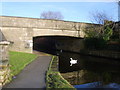
Bridge 104, Lancaster Canal
Ridge Bridge easily recognised by the graffiti provided free of charge by the children from the nearby estate.
Image: © Michael Graham
Taken: 10 Dec 2009
0.09 miles
