IMAGES TAKEN NEAR TO
Coniston Road, LANCASTER, LA1 3NW
Introduction
This page details the photographs taken nearby to Coniston Road, LA1 3NW by members of the Geograph project.
The Geograph project started in 2005 with the aim of publishing, organising and preserving representative images for every square kilometre of Great Britain, Ireland and the Isle of Man.

There are currently over 7.5m images from over14,400 individuals and you can help contribute to the project by visiting https://www.geograph.org.uk
Image Map
Images are licensed for reuse under creativecommons.org/licenses/by-sa/2.0
Notes
- Clicking on the map will re-center to the selected point.
- The higher the marker number, the further away the image location is from the centre of the postcode.
Image Listing (29 Images Found)
Images are licensed for reuse under creativecommons.org/licenses/by-sa/2.0
Image
Details
Distance
2
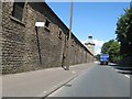
Heading north through the Newton district of Lancaster
Passing a river side industrial area in what appears to have been barracks.
Image: © James Denham
Taken: 23 Jun 2014
0.08 miles
3
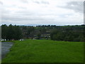
On the Ridge
On the edge of the Ridge a council estate in Lancaster. Looking over the bay the ever present Black Comb
Image: © Michael Graham
Taken: 6 Sep 2008
0.09 miles
4
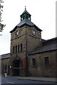
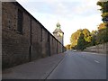
Lancaster Wagon Works - clock tower
The Lancaster Railway Carriage and Wagon Company moved into these new premises in 1865, adjacent to the Midland Railway line to Leeds. The works were taken over by the Metropolitan Amalgamated Railway Carriage and Wagon Company in 1902 and closed in 1908.
The works were used in the First World War, firstly as a base for the 5th Battalion King's Own Royal Lancaster Regiment, then as an internment camp for enemy aliens, and finally to manufacture torpedoes.
In 1923, Morton's (of Carlisle) took over the works to manufacture carpets and furnishing materials. Today, high-quality printing of fabrics is carried out, under the name of Standfast.
See http://list.english-heritage.org.uk/resultsingle.aspx?uid=1298408
(Historical details provided by Lancaster Civic Society, who arranged for the works to be opened for Heritage Weekend 2014.)
Image: © Ian Taylor
Taken: 14 Sep 2014
0.09 miles
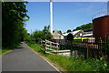
5
The clock tower, Caton Road, Lancaster
Built for the Lancaster Railway Carriage and Wagon Company; the premises are now a business park. The tower lies on a gridline
Image: © David Smith
Taken: 2 Oct 2016
0.09 miles
6
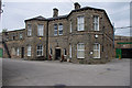
Lancaster Wagon Works - offices
The Lancaster Railway Carriage and Wagon Company moved into these new premises in 1865, adjacent to the Midland Railway line to Leeds. The works were taken over by the Metropolitan Amalgamated Railway Carriage and Wagon Company in 1902 and closed in 1908.
The works were used in the First World War, firstly as a base for the 5th Battalion King's Own Royal Lancaster Regiment, then as an internment camp for enemy aliens, and finally to manufacture torpedoes.
In 1923, Morton's (of Carlisle) took over the works to manufacture carpets and furnishing materials. Today, high-quality printing of fabrics is carried out, under the name of Standfast.
See http://list.english-heritage.org.uk/resultsingle.aspx?uid=1298408
(Historical details provided by Lancaster Civic Society, who arranged for the works to be opened for Heritage Weekend 2014.)
Image: © Ian Taylor
Taken: 14 Sep 2014
0.11 miles
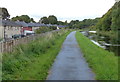
7
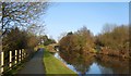
Lancaster Canal
Above Lansil Social Club
Image: © Michael Graham
Taken: 10 Dec 2009
0.12 miles
8
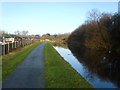
Lancaster Canal
The houses of Newton Estate on the left
Image: © Michael Graham
Taken: 10 Dec 2009
0.12 miles
9
Turf zone Caton
Riverside path towards Lune Aqueduct.
Image: © Ian S
Taken: 27 May 2023
0.13 miles
10
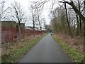
Jogger on the Lune Valley Ramble
Heading into Lancaster on a former railway line, alongside Lappet Dyehouse.
Image: © Christine Johnstone
Taken: 9 Mar 2015
0.13 miles