
IMAGES TAKEN NEAR TO
Main Street, ULVERSTON, LA12 9QT
Introduction
This page details the photographs taken nearby to Main Street, LA12 9QT by members of the Geograph project.
The Geograph project started in 2005 with the aim of publishing, organising and preserving representative images for every square kilometre of Great Britain, Ireland and the Isle of Man.

There are currently over 7.5m images from over14,400 individuals and you can help contribute to the project by visiting https://www.geograph.org.uk
Image Map
Images are licensed for reuse under creativecommons.org/licenses/by-sa/2.0
Notes
- Clicking on the map will re-center to the selected point.
- The higher the marker number, the further away the image location is from the centre of the postcode.
Image Listing (61 Images Found)
Images are licensed for reuse under creativecommons.org/licenses/by-sa/2.0
Image
Details
Distance

2

The Ship Inn
Located in Bardsea village, to the south of Ulverston.
Image: © Mary and Angus Hogg
Taken: 22 Feb 2018
0.03 miles

4

Ordnance Survey Cut Mark
This OS cut mark can be found on the NW angle of Holy Trinity Church. It marks a point 32.533m above mean sea level.
Image: © Adrian Dust
Taken: 10 Oct 2019
0.04 miles
5

Holy Trinity Church
Detail of the north west corner of the tower of Holy Trinity Church.
There is an Ordnance Survey cut benchmark near the bottom of the buttress (photograph Image).
Image: © Adrian Taylor
Taken: 2 Jul 2022
0.04 miles
6
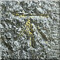
Bench mark, Holy Trinity Church, Bardsea
Detail of the Ordnance Survey cut bench mark on the buttress on the north west angle of the tower of Holy Trinity Church. The benchmark marks a height of 32.5325m above mean sea level (Ordnance Datum Newlyn) last verified in 1968 (location photograph Image).
The bench mark bears traces of yellow waxed crayon, most likely applied when the bench mark was highlighted for ease of location when in use as a survey datum.
Image: © Adrian Taylor
Taken: 2 Jul 2022
0.04 miles

8

Bardsea
The view of the village from the sea shore.
Image: © Anne Burgess
Taken: 3 Jan 2026
0.04 miles
9

Ordnance Survey Cut Mark
This mark can be found on the wall of Holy Trinity Church at Bardsea. The benchmark height is recorded as being 32.533 metres above sea level.
For more detail see : https://www.bench-marks.org.uk/bm71208
Image: © Peter Wood
Taken: 31 Oct 2018
0.04 miles
