IMAGES TAKEN NEAR TO
Fell Side, ULVERSTON, LA12 8QW
Introduction
This page details the photographs taken nearby to Fell Side, LA12 8QW by members of the Geograph project.
The Geograph project started in 2005 with the aim of publishing, organising and preserving representative images for every square kilometre of Great Britain, Ireland and the Isle of Man.

There are currently over 7.5m images from over14,400 individuals and you can help contribute to the project by visiting https://www.geograph.org.uk
Image Map
Images are licensed for reuse under creativecommons.org/licenses/by-sa/2.0
Notes
- Clicking on the map will re-center to the selected point.
- The higher the marker number, the further away the image location is from the centre of the postcode.
Image Listing (56 Images Found)
Images are licensed for reuse under creativecommons.org/licenses/by-sa/2.0
Image
Details
Distance
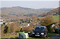
6
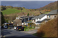
Backbarrow
The A590, running north-south in the centre of the photo, effectively cuts the village in half.
Image: © E Gammie
Taken: 7 Nov 1997
0.11 miles
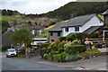
7
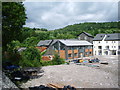
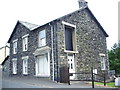
New houses on Backbarrow Ironworks
Image: © Alexander P Kapp
Taken: 11 Jun 2008
0.13 miles
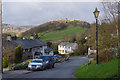
8
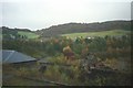
Backbarrow ironworks
Looking across Backbarrow ironworks towards Backbarrow and Fell Side. Taken from the Lakeside and Haverthwaite Railway.
Image: © E Gammie
Taken: 2 Nov 1997
0.13 miles