IMAGES TAKEN NEAR TO
Bouth, ULVERSTON, LA12 8JN
Introduction
This page details the photographs taken nearby to LA12 8JN by members of the Geograph project.
The Geograph project started in 2005 with the aim of publishing, organising and preserving representative images for every square kilometre of Great Britain, Ireland and the Isle of Man.

There are currently over 7.5m images from over14,400 individuals and you can help contribute to the project by visiting https://www.geograph.org.uk
Image Map
Images are licensed for reuse under creativecommons.org/licenses/by-sa/2.0
Notes
- Clicking on the map will re-center to the selected point.
- The higher the marker number, the further away the image location is from the centre of the postcode.
Image Listing (6 Images Found)
Images are licensed for reuse under creativecommons.org/licenses/by-sa/2.0
Image
Details
Distance
3
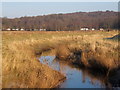
Rusland Pool looking towards Black Beck caravan park
Image: © Andrew Hill
Taken: 29 Dec 2008
0.22 miles
5
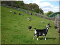
Small goats at Black Beck
The new kids on the block were bouncing around full of the joys of Spring.
Image: © Karl and Ali
Taken: 28 Apr 2012
0.24 miles
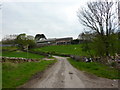
6
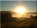
Sun Rise over Black Beck Farm
It doesn't get much more beautiful than this :)
Image: © Caroline Hampton
Taken: 23 Aug 2008
0.24 miles