
IMAGES TAKEN NEAR TO
Stockbridge Lane, ULVERSTON, LA12 7NL
Introduction
This page details the photographs taken nearby to Stockbridge Lane, LA12 7NL by members of the Geograph project.
The Geograph project started in 2005 with the aim of publishing, organising and preserving representative images for every square kilometre of Great Britain, Ireland and the Isle of Man.

There are currently over 7.5m images from over14,400 individuals and you can help contribute to the project by visiting https://www.geograph.org.uk
Image Map
Images are licensed for reuse under creativecommons.org/licenses/by-sa/2.0
Notes
- Clicking on the map will re-center to the selected point.
- The higher the marker number, the further away the image location is from the centre of the postcode.
Image Listing (67 Images Found)
Images are licensed for reuse under creativecommons.org/licenses/by-sa/2.0
Image
Details
Distance
1

Bullock looking over a wall
On Stockbridge Lane, Ulverston.
Image: © Stephen Craven
Taken: 17 Oct 2020
0.01 miles
2

Stonecross Garden, Ulverston
Off Stockbridge Lane.
Image: © Stephen Craven
Taken: 17 Oct 2020
0.03 miles
3

Ordnance Survey Cut Mark
This OS cut mark can be found on the gatepost at the junction of the path and Stockbridge Lane. It marks a point 58.7548m above mean sea level.
Image: © Adrian Dust
Taken: 17 Oct 2019
0.06 miles
4
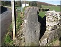
Stile adjacent to Stockbridge Lane
The Cumbria Way long distance footpath passes through this stile adjacent to Stockbridge Lane, then follows the stone wall across the top of the field beyond (next photograph Image). There is an Ordnance Survey cut benchmark visible on the face of the slate gatepost (photograph Image).
Image: © Adrian Taylor
Taken: 10 Feb 2016
0.06 miles
5
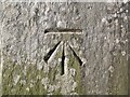
Benchmark, Stock Bridge Lane
Detail of the Ordnance Survey cut benchmark on a slate gatepost adjacent to Stock Bridge Lane and beside The Cumbria Way long distance path. The benchmark marks a height of 58.755m above sea level (Ordnance Datum Newlyn) last verified in 1968 (location photograph Image).
Image: © Adrian Taylor
Taken: 10 Feb 2016
0.06 miles
6
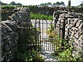
The Cumbria Way, Stockbridge Lane
The iron kissing gate guards the end of the footpath from Gill Banks before it leads onto Stockbridge Lane.
The Cumbria Way passes through the gate and turns sharp right through a stile in the wall between the gate and the road (next photograph Image).
Image: © Adrian Taylor
Taken: 10 Jun 2018
0.06 miles
7

Cumbria Way finger post and narrow gap stile
Just out of Ulverston this wet scene sets the tone for the 16 mile walk to Coniston, my camera just made it, although I missed a few squares to geograph
Image: © Martin Dawes
Taken: 5 Jun 2017
0.06 miles
8

Ordnance Survey Cut Mark
This mostly buried OS cut mark can be found on the wall NE side of Stockbridge Lane. It marks a point 50.886m above mean sea level.
Image: © Adrian Dust
Taken: 17 Oct 2019
0.06 miles
9

Cumbria Way link path
The footpath across a field leads to the Cumbria Way in the valley below.
Image: © Stephen Craven
Taken: 17 Oct 2020
0.06 miles
