
IMAGES TAKEN NEAR TO
The Gill, ULVERSTON, LA12 7BP
Introduction
This page details the photographs taken nearby to The Gill, LA12 7BP by members of the Geograph project.
The Geograph project started in 2005 with the aim of publishing, organising and preserving representative images for every square kilometre of Great Britain, Ireland and the Isle of Man.

There are currently over 7.5m images from over14,400 individuals and you can help contribute to the project by visiting https://www.geograph.org.uk
Image Map
Images are licensed for reuse under creativecommons.org/licenses/by-sa/2.0
Notes
- Clicking on the map will re-center to the selected point.
- The higher the marker number, the further away the image location is from the centre of the postcode.
Image Listing (212 Images Found)
Images are licensed for reuse under creativecommons.org/licenses/by-sa/2.0
Image
Details
Distance
1
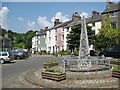
The Cumbria Way Monument, Ulverston
This metal and stone monument, also referred to as The Cumbria Way Waymarker, was unveiled in 2000 and commemorates The Cumbria Way long distance footpath which runs from Ulverston to Carlisle.
The official start of The Cumbria Way is where the road leaves The Gill beside the houses in the background.
The walking route from Ulverston Station and town centre to the start of The Cumbria Way passes the monument (next photograph Image).
Image: © Adrian Taylor
Taken: 10 Jun 2018
0.00 miles
2
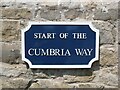
Start of The Cumbria Way sign
Detail of the sign indicating the official start of The Cumbria Way long distance footpath from Ulverston to Carlisle.
Image: © Adrian Taylor
Taken: 10 Jun 2018
0.02 miles
3
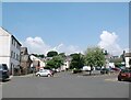
The Gill, Ulverston
Viewed from near the top of Upper Brook Street.
What was at one time an open tarmacked area is now a pay and display car park and host to areas of planting and semi-mature trees.
This is the walking route from Ulverston Station and town centre to the start of The Cumbria Way long distance footpath (next photograph Image).
Image: © Adrian Taylor
Taken: 10 Jun 2018
0.02 miles
4
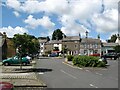
The Gill, Ulverston
What was at one time an open tarmacked area is now a pay and display car park and host to areas of planting and semi-mature trees.
This is the walking route from Ulverston Station and town centre to the start of The Cumbria Way long distance footpath (next photograph Image). The monument commemorating The Cumbria Way is visible in the background.
Image: © Adrian Taylor
Taken: 27 Jun 2007
0.02 miles
5

Ulverston- Start of the Cumbria Way at The Gill
Image: © Colin Park
Taken: 23 Jul 2018
0.02 miles
6

Cumbria Waymarker. The Gill. Ulverston
Nice to see it in sunshine. The spire contains rocks that represent the geology along the route. At the base is limestone, slate in the middle and red sandstone at the top. A useful if simple mnemonic of the route south to north. This is the start of the Cumbria Way 73 miles to Carlisle. We split it into 5 days, it rained for three and a half, splendid waterfalls!!
Image: © Martin Dawes
Taken: 4 Jun 2017
0.02 miles
7

Start of the Cumbria Way in Ulverston
The 112km long distance footpath starts in The Gill, the upper square of the town centre, and is marked by a metal sculpture Image
Image: © Stephen Craven
Taken: 17 Oct 2020
0.02 miles
8

Upper Brook Street, Ulverston
Leading from King Street, the top of Upper Brook Street opens into The Gill.
This is the walking route from Ulverston Station and town centre to the start of The Cumbria Way long distance footpath (next photograph Image).
Image: © Adrian Taylor
Taken: 10 Jun 2018
0.02 miles
9

NHS bench, The Gill, Ulverston
The bench was presumably decorated in honour of NHS staff during the 2020 Covid-19 pandemic.
Image: © Stephen Craven
Taken: 17 Oct 2020
0.03 miles
10

Ordnance Survey Cut Mark
This OS cut mark can be found on No3 Union Lane. It marks a point 37.599m above mean sea level.
Image: © Adrian Dust
Taken: 17 Oct 2019
0.03 miles