
IMAGES TAKEN NEAR TO
Pennington Lane, ULVERSTON, LA12 0LA
Introduction
This page details the photographs taken nearby to Pennington Lane, LA12 0LA by members of the Geograph project.
The Geograph project started in 2005 with the aim of publishing, organising and preserving representative images for every square kilometre of Great Britain, Ireland and the Isle of Man.

There are currently over 7.5m images from over14,400 individuals and you can help contribute to the project by visiting https://www.geograph.org.uk
Image Map
Images are licensed for reuse under creativecommons.org/licenses/by-sa/2.0
Notes
- Clicking on the map will re-center to the selected point.
- The higher the marker number, the further away the image location is from the centre of the postcode.
Image Listing (21 Images Found)
Images are licensed for reuse under creativecommons.org/licenses/by-sa/2.0
Image
Details
Distance
1

Lindal in Furness : Ulverston Road A590
Looking along Ulverston Road.
Image: © Lewis Clarke
Taken: 24 Sep 2019
0.10 miles
2
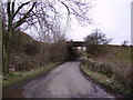
Old Bridge Lindal
A scruffy area of old mines and untidy farmland just outside Lindal. The old bridge looks like it may have carried a railway perhaps connected with the disused Iron Mines all over the area. The 1940 OS map does not show a railway however.
Image: © Michael Graham
Taken: Unknown
0.10 miles
3

Pennington : Ulverston Road A590
Heading through Pennington on the A590.
Image: © Lewis Clarke
Taken: 24 Sep 2019
0.11 miles
4
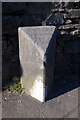
Old Boundary Marker on the A590 Ulverston Road
Municipal Boundary Marker in Lindal in Furness, against a short length of stone wall beside No.45, on the northeast side of the A590 Ulverston Road. The inscriptions are reported to be DALTON / IN / FURNESS / UDC and LOW / FURNESS on adjacent faces, and BOUNDARY on the bevelled top face.
Old OS maps don't show a boundary here until 1935. It is possible that the stone was moved from SD2523175891. Dalton in Furness UDC, consisting of Dalton in Furness parish, was created in 1894 and the neighbouring local government unit would have been Pennington parish in Ulverston Rural District. Dalton in Furness parish was abolished in 1974. The current boundary is between Lindal and Marton and Pennington parish. Lindal and Marton was created in 1987 along with two other parishes from the former area of Dalton in Furness.
Milestone Society National ID: LA_LABA39pb
Image: © Colin Smith
Taken: 23 Apr 2007
0.12 miles
6
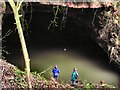
Iron Ore Mine
The Blue Trousers contrast with the drab, now flooded forbidding entrance which gave access to miles of underground workings to this mine known as 'Daylight Hole'.
Image: © Arnold Price
Taken: 1 Feb 2007
0.16 miles
7
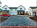
Anchor Gardens, Lindal in Furness
Built on the site of the Anchor Hotel
Image: © Alexander P Kapp
Taken: 23 Apr 2013
0.17 miles
8
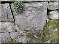
Ordnance Survey Cut Mark
This OS cut mark can be found on the NW abutment of the disused railway bridge. It marks a point 75.034m above mean sea level.
Image: © Adrian Dust
Taken: 25 Feb 2022
0.18 miles
10
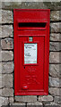
Elizabeth II postbox on Pit Lane, Lindal in Furness
Postbox No. LA12 74.
See Image] for context
Image: © JThomas
Taken: 4 Jul 2021
0.22 miles