
IMAGES TAKEN NEAR TO
Wheatfield Mews, LANCASTER, LA1 1UB
Introduction
This page details the photographs taken nearby to Wheatfield Mews, LA1 1UB by members of the Geograph project.
The Geograph project started in 2005 with the aim of publishing, organising and preserving representative images for every square kilometre of Great Britain, Ireland and the Isle of Man.

There are currently over 7.5m images from over14,400 individuals and you can help contribute to the project by visiting https://www.geograph.org.uk
Image Map
Images are licensed for reuse under creativecommons.org/licenses/by-sa/2.0
Notes
- Clicking on the map will re-center to the selected point.
- The higher the marker number, the further away the image location is from the centre of the postcode.
Image Listing (290 Images Found)
Images are licensed for reuse under creativecommons.org/licenses/by-sa/2.0
Image
Details
Distance
1
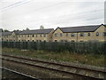
Wheatfield Mews, Lancaster
Seen from the railway, south of the station. Built between 2014 and 2018.
Image: © M J Richardson
Taken: 24 Oct 2021
0.03 miles
2

Topiary on Blades Street
Showing that an Englishman's home is his castle, and revealing the answer to the ultimate question.
Image: © Ian Taylor
Taken: 12 Sep 2014
0.04 miles
3

Turf zone ParkByDallas
Dallas Road Gardens, Lancaster.
Image: © Ian S
Taken: 27 May 2023
0.08 miles
4
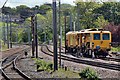
Network Rail tamping machine, Lancaster railway station
Seen in a siding alongside the West Coast Main Line, alongside a tangle of catenary, looking south from the southern end of the platform.
Image: © El Pollock
Taken: 29 May 2015
0.08 miles
5

Dallas Road
Looking south down Dallas Road
Image: © Alexander P Kapp
Taken: 16 May 2007
0.09 miles
6
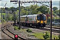
First TransPennine Express Class 350, 350407, Lancaster railway station
The train approaches Lancaster station from the south, with a service to Scotland.
Image: © El Pollock
Taken: 29 May 2015
0.10 miles
7

Dallas Road
Dallas Road from its junction with Meeting House Lane
Image: © Alexander P Kapp
Taken: 16 May 2007
0.11 miles
8

OS Bench Mark
OS cut bench mark from the 20th century levelling on No.13 Lindow Square. 25.942 m above datum.
Image: © Phil Johnstone
Taken: 17 Oct 2021
0.11 miles
10

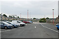
Benchmark on No. 16 Dallas Road
Ordnance Survey records indicate the mark was levelled at 19.903m above Newlyn Datum and verified in 1960
Image: © Luke Shaw
Taken: 5 Jul 2019
0.13 miles