IMAGES TAKEN NEAR TO
Monville Road, LIVERPOOL, L9 9DE
Introduction
This page details the photographs taken nearby to Monville Road, L9 9DE by members of the Geograph project.
The Geograph project started in 2005 with the aim of publishing, organising and preserving representative images for every square kilometre of Great Britain, Ireland and the Isle of Man.

There are currently over 7.5m images from over14,400 individuals and you can help contribute to the project by visiting https://www.geograph.org.uk
Image Map (Loading...)


Getting Data...Please wait
Leaflet Map data © OpenStreetMap
Images are licensed for reuse under creativecommons.org/licenses/by-sa/2.0
Notes
- Clicking on the map will re-center to the selected point.
- The higher the marker number, the further away the image location is from the centre of the postcode.
Image Listing (27 Images Found)
Images are licensed for reuse under creativecommons.org/licenses/by-sa/2.0
Image
Details
Distance
2
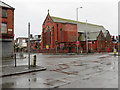
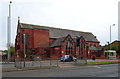
Emmanuel Church, Fazakerley
Looking across the junction of Long Moor Lane and Higher Lane towards the Emmanuel Church.
Image: © John S Turner
Taken: 23 Dec 2013
0.07 miles
3
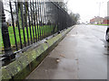
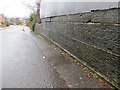
Rivet bench mark in Long Moor Lane, Fazakerley
Looking along Long Moor Lane with the railings of the cemetery on the left. There is a rivet bench mark below the larger post on the left. Image
Image: © John S Turner
Taken: 23 Dec 2013
0.08 miles
4
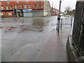
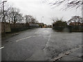
Junction of Seeds Lane and Long Moor Lane
Looking across the junction of Seeds Lane and Long Moor Lane, with Higher Lane opposite. There is a rivet bench mark at the bottom right of the photo Image
Image: © John S Turner
Taken: 23 Dec 2013
0.09 miles
5
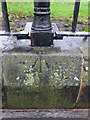
Rivet bench mark in Long Moor Lane, Fazakerley
This rivet bench mark is cut into the wall around Kirkdale Cemetery in Long Moor Lane, Fazakerley. See also Image
Image: © John S Turner
Taken: 23 Dec 2013
0.09 miles
6
Junction of Higher Lane with Sandy Lane, Fazakerley
Looking south along Higher Lane where Sandy Lane joins from the right. Just ahead is a railway bridge that has an Ordnance Survey bench mark on its right/west parapet.
Image: © John S Turner
Taken: 23 Dec 2013
0.09 miles
7
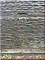
Bench mark on Higher Lane railway bridge, Fazakerley
This Ordnance Survey bench mark is on the west parapet of Higher Lane railway bridge. See also Image
For details of the mark see: http://www.bench-marks.org.uk/bm53513
Image: © John S Turner
Taken: 23 Dec 2013
0.09 miles
8
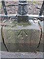
Rivet bench mark near the junction of Seeds Lane and Long Moor Lane
This rivet bench mark is close to the curved corner of the cemetery railings near the junction of Seeds Lane and Long Moor Lane. See also Image
Image: © John S Turner
Taken: 23 Dec 2013
0.09 miles
9
Higher Lane bridge parapet, and a bench mark
Looking along the west parapet of Higher Lane railway bridge. There is an Ordnance Survey cut bench mark near the right hand edge of the photo. See Image
Image: © John S Turner
Taken: 23 Dec 2013
0.12 miles
10
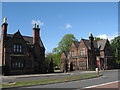
Lodges, Kirkdale Cemetery
Although named Kirkdale Cemetery, this cemetery, which opened in 1881, is actually in Longmoor Lane, Fazakerley
A large Canadian hospital opened at Kirkdale in July 1917 and of the 386 First World War burials in this cemetery, more than 100 are Canadian. Of the remainder, 82 are of officers and men of the King's (Liverpool) Regiment. There are two war graves plots, where the names of the dead are recorded on screen wall panels. There are also 115 Second World War burials, nine of them in one of the First World War plots, the rest scattered. This cemetery also contains nine war graves of other nationalities, originally there were many more, including American and German from the First World War and Belgian from both wars, but these were later removed to other national cemeteries in the United Kingdom or repatriated to their home country.
Image: © Sue Adair
Taken: 15 May 2012
0.14 miles