IMAGES TAKEN NEAR TO
Damsire Close, LIVERPOOL, L9 9BF
Introduction
This page details the photographs taken nearby to Damsire Close, L9 9BF by members of the Geograph project.
The Geograph project started in 2005 with the aim of publishing, organising and preserving representative images for every square kilometre of Great Britain, Ireland and the Isle of Man.

There are currently over 7.5m images from over14,400 individuals and you can help contribute to the project by visiting https://www.geograph.org.uk
Image Map
Images are licensed for reuse under creativecommons.org/licenses/by-sa/2.0
Notes
- Clicking on the map will re-center to the selected point.
- The higher the marker number, the further away the image location is from the centre of the postcode.
Image Listing (16 Images Found)
Images are licensed for reuse under creativecommons.org/licenses/by-sa/2.0
Image
Details
Distance
1
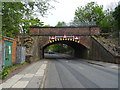
Disused railway bridge over Seeds Lane
Now used by a cycle path.
Image: © JThomas
Taken: 28 Apr 2019
0.03 miles
2
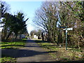
Trans Pennine Trail signage on the Liverpool Loop Line
View from the trackbed of the dismantled railway crossing Seeds Lane
Image: © Raymond Knapman
Taken: 21 Feb 2014
0.03 miles
3
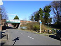
Trans Pennine Trail signage on the Liverpool Loop Line
A dismantled railway line bridge is used for the Liverpool end of the trail
Image: © Raymond Knapman
Taken: 21 Feb 2014
0.04 miles
4
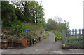
Access to Trans Pennine Trail Loop Line
On a disused railway off Seeds Lane.
Image: © JThomas
Taken: 28 Apr 2019
0.04 miles
5
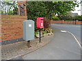
Elizabeth II postbox on Seeds Lane
Postbox No. L9 409.
See Image] for close up.
Image: © JThomas
Taken: 28 Apr 2019
0.07 miles
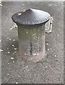
6
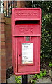
Close up, Elizabeth II postbox on Seeds Lane
Postbox No. L9 409.
See Image] for wider view.
Image: © JThomas
Taken: 28 Apr 2019
0.07 miles
8
Aintree Racecourse
This is the view from the Melling Road crossing looking down the Grand National course.
Image: © Nigel Cox
Taken: 16 Jun 2007
0.14 miles
9
Old Boundary Marker on Seeds Lane, Liverpool
Parish Boundary Marker on the east side of the T junction of Seeds Lane and Melling Road. Now on the boundary of Liverpool and Aintree Village parish. In 1877 the boundary was Walton on the Hill and Aintree parishes but the particular significance of 1877 is unknown. ERECTED BY THE OVERSEERS 1877 in raised lettering around the top edge.
Milestone Society National ID: LA_LVAI01pb
Image: © J Kelly
Taken: 3 Sep 2021
0.16 miles
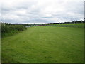
10
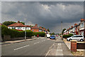
Melling Road
With bit of a threat in the sky
Image: © Ian Greig
Taken: 8 Aug 2014
0.16 miles