IMAGES TAKEN NEAR TO
Montgomery Road, LIVERPOOL, L9 8DQ
Introduction
This page details the photographs taken nearby to Montgomery Road, L9 8DQ by members of the Geograph project.
The Geograph project started in 2005 with the aim of publishing, organising and preserving representative images for every square kilometre of Great Britain, Ireland and the Isle of Man.

There are currently over 7.5m images from over14,400 individuals and you can help contribute to the project by visiting https://www.geograph.org.uk
Image Map (18 Images)


Leaflet Map data © OpenStreetMap
Images are licensed for reuse under creativecommons.org/licenses/by-sa/2.0
Notes
- Clicking on the map will re-center to the selected point.
- The higher the marker number, the further away the image location is from the centre of the postcode.
Image Listing (18 Images Found)
Images are licensed for reuse under creativecommons.org/licenses/by-sa/2.0
Image
Details
Distance
1

Ormskirk line railway bridge
The bridge carries the Liverpool to Ormskirk line over the former Liverpool Extension line, now a Sustrans route.
Image: © Stephen Craven
Taken: 4 Nov 2017
0.03 miles
2

Bull Lane bridge
The bridge carries what used to be a through road, but now only a footpath, over the former Liverpool Extension line, now a Sustrans route.
Image: © Stephen Craven
Taken: 4 Nov 2017
0.09 miles
4

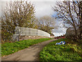
Overgrown railway cutting, Aintree
At this point the Sustrans route leaves the trackbed of the Liverpool Extension Line (Cheshire Lines) and rises up to meet the former Litherland line. This view looks down into the overgrown cutting of the CLC route.
Image: © Stephen Craven
Taken: 4 Nov 2017
0.13 miles
5
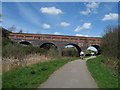
Trans Pennine Trail, Aintree
Railway viaduct on the Trans Pennine Trail near Aintree Station, part of the National Cycleway Network Route 62.
Image: © Sue Adair
Taken: 11 Apr 2009
0.16 miles
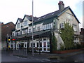
6
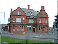
The Black Bull
Big pub in north of Walton, the surrounding area is named after the pub.
Image: © Peter Hodge
Taken: 7 Jan 2006
0.16 miles
7
Bridge to Helsby Road
This was once part of Bull Lane (see also Image ) where it crossed the Liverpool to Aintree railway, but now just a footpath link to NCN62.
Image: © Stephen Craven
Taken: 4 Nov 2017
0.18 miles
8

Signpost on NCN62, Aintree
A three-way signpost where there is an entry/exit point to/from Helsby Avenue.
Image: © Stephen Craven
Taken: 4 Nov 2017
0.18 miles
9
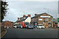
Warbreck Moor, Walton
At the junction with Hall Lane.
Image: © Mike Pennington
Taken: 22 Oct 2015
0.18 miles
10
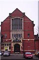
Aintree Institute
The Beatles made 31 appearances here 7 January 1961 - 27 January 1962.
Image: © S Parish
Taken: 2 Feb 2006
0.19 miles