IMAGES TAKEN NEAR TO
Hartley Avenue, LIVERPOOL, L9 7DB
Introduction
This page details the photographs taken nearby to Hartley Avenue, L9 7DB by members of the Geograph project.
The Geograph project started in 2005 with the aim of publishing, organising and preserving representative images for every square kilometre of Great Britain, Ireland and the Isle of Man.

There are currently over 7.5m images from over14,400 individuals and you can help contribute to the project by visiting https://www.geograph.org.uk
Image Map (14 Images)


Getting Data...Please wait
Leaflet Map data © OpenStreetMap
Images are licensed for reuse under creativecommons.org/licenses/by-sa/2.0
Notes
- Clicking on the map will re-center to the selected point.
- The higher the marker number, the further away the image location is from the centre of the postcode.
Image Listing (14 Images Found)
Images are licensed for reuse under creativecommons.org/licenses/by-sa/2.0
Image
Details
Distance
1
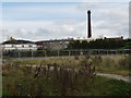
Hartleys factory chimney, Aintree
The chimney remains as an icon of the former jam factory. William Hartley opened his factory here in 1886 but it closed some time in the late 20th century and is now an industrial estate with several businesses. See Image for the original main factory building and Image for Hartley's later factory in London.
The buildings in the foreground are those of Blessed Sacrament Catholic Primary School.
Image: © Stephen Craven
Taken: 4 Nov 2017
0.01 miles
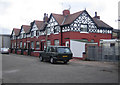
2
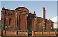
A building in Hartley Avenue
This is part of the Hartley Village Conservation Area which was established in 2011 to protect this example of Victorian philanthropy. The grade II listed jam making factory was founded in 1886 and built together with workers’ houses and recreational facilities nearby.
Image: © Ian Greig
Taken: 14 Nov 2014
0.06 miles
3
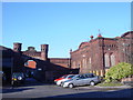
Hartleys Jam Factory
The ruin of Hartleys Jam Factory built in 1886, twelve years after William Hartley made his first jam at Aintree. The factory employed 1,200 workers, many of whom took advantage of the purpose built houses let on the hire-purchase scheme, a similar project to that of Lord Leverhulme in Port Sunlight. Hartley was a philanthropist who pioneered profit-sharing, pensions, health service and recreational facilities for his employees as well as giving huge sums of money to charity.
Image: © Sue Adair
Taken: 14 Jan 2006
0.06 miles
4
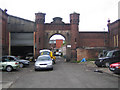
Liverpool: The former Hartley's jam factory
These are the forlorn remains of Hartley's jam factory which was completed in 1886. The carving in the stone pediment over the arch reads "W P Hartley" after William Pickles Hartley.
Image: © Nigel Cox
Taken: 16 Jun 2007
0.06 miles
5
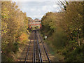
Kirkby line to the east of NCN62
The electrified route to Kirkby, with Long Lane road bridge.
Image: © Stephen Craven
Taken: 4 Nov 2017
0.10 miles
6
Liverpool: Hartley's Village
When William Pickles Hartley moved his jam-making business to Aintree in 1885 his philanthropy extended to constructing houses for his workers. The jam factory may now have gone but the houses survive. This terrace is in Spice Street.
Image: © Nigel Cox
Taken: 16 Jun 2007
0.12 miles
7
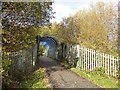
Footbridge over the Kirkby line
A railway bridge once carried the former Liverpool Extension Line over the electrified route to Kirkby. This present, narrow bridge is obviously not the original and is part of the Sustrans path that now follows the route.
Image: © Stephen Craven
Taken: 4 Nov 2017
0.14 miles
8
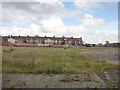
Site of demolished school, Walton Vale
The Blessed Sacrament Junior School was on this site until recently. In the background are houses on Cedar Road.
Image: © Stephen Craven
Taken: 4 Nov 2017
0.15 miles
9
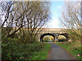
Hartley Avenue bridge (1)
This substantial, multi-arch bridge crosses the site of Fazakerley Junction. The main arch crossed what is now the Sustrans path and was the main line to Aintree; to the right one smaller arch covered sidings to nearby factories (including Hartleys Jam, hence the name of the road); and to the left, the LMSR goods lines to Bootle Docks. There is virtually no trace of the railway today.
Image: © Stephen Craven
Taken: 4 Nov 2017
0.15 miles
10
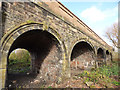
Hartley Avenue bridge (2)
This substantial, multi-arch bridge crosses the site of Fazakerley Junction. To the left of the photo a flat span crossed LMSR goods lines to Bootle Docks. The nearest arch in this photo looks too narrow to have crossed a railway track, but further arches crossed the main CLC line to Aintree and sidings to nearby factories (including Hartleys Jam, hence the name of the road).
Image: © Stephen Craven
Taken: 4 Nov 2017
0.16 miles