IMAGES TAKEN NEAR TO
Torrisholme Road, LIVERPOOL, L9 6AT
Introduction
This page details the photographs taken nearby to Torrisholme Road, L9 6AT by members of the Geograph project.
The Geograph project started in 2005 with the aim of publishing, organising and preserving representative images for every square kilometre of Great Britain, Ireland and the Isle of Man.

There are currently over 7.5m images from over14,400 individuals and you can help contribute to the project by visiting https://www.geograph.org.uk
Image Map (Loading...)


Getting Data...Please wait
Leaflet Map data © OpenStreetMap
Images are licensed for reuse under creativecommons.org/licenses/by-sa/2.0
Notes
- Clicking on the map will re-center to the selected point.
- The higher the marker number, the further away the image location is from the centre of the postcode.
Image Listing (15 Images Found)
Images are licensed for reuse under creativecommons.org/licenses/by-sa/2.0
Image
Details
Distance
1
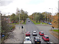
Walton Hall Avenue looking east
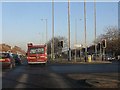
A view from the former railway bridge Image The road is the dual-carriageway A580 (East Lancashire Road).
Image: © Stephen Craven
Taken: 4 Nov 2017
0.11 miles
2
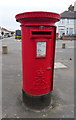
Elizabeth II postbox on Stopgate Lane
Outside the Post Office.
Postbox No. L9 759.
See Image] for context.
Image: © JThomas
Taken: 28 Apr 2019
0.14 miles
3
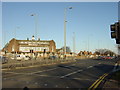
Dickie Lewis's - Junction of East Lancs Road
The photograph shows the infamous Crown public house, renamed Dickie Lewis's in January 2006. Situated at the busy junction of Stopgate Lane with the East Lancs Road it had been named 39th in Merseyside's top 100 grot spots. It was the site of numerous arson attacks having been left to rot because it was not in a regeneration zone. The building’s owners plan to convert the pub into apartments was knocked back by the council and a government planning inspector as it did not fall into one of Liverpool’s housing renewal areas.
It has recently been demolished.
Image: © Sue Adair
Taken: 14 Jan 2006
0.14 miles
4
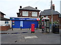
Post Office and shop on Stopgate Lane
Showing position of Postbox No. L9 759.
See Image] for postbox.
Image: © JThomas
Taken: 28 Apr 2019
0.15 miles
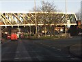
5
The A580 at Walton Hall Avenue Bridge, Liverpool
Image: © Ian S
Taken: 8 May 2011
0.16 miles
6
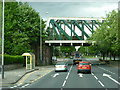
Bridge over Walton Hall Avenue
Similar to the bridge a little further south over Townsend Avenue Image, the reason for this substantial structure is that the railway crossed the dual carriageway Walton Hall Avenue (A580) at this point in a single span of about 45 metres. Therefore a deep truss bridge that contains the stresses within itself gave ore clearance than a traditional arch. See Image for a side view.
Image: © Stephen Craven
Taken: 4 Nov 2017
0.16 miles
7
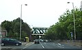
Walton Hall Avenue Bridge Crosses the A580
Image: © Anthony Parkes
Taken: 23 Sep 2012
0.16 miles
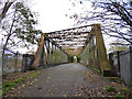
8
Cheshire Lines railway bridge, Walton Hall Avenue
The redundant bridge which once carried the Southport branch of the Cheshire Lines Committee railway line.
Image: © Peter Whatley
Taken: 17 Jan 2012
0.16 miles
9
Strawberry Lane traffic lights
The A580 is crossed by the B5187 here.
Image: © Peter Whatley
Taken: 17 Jan 2012
0.17 miles
10
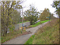
Exit to Blackthorne Road
One of the access points to/from National Cycle Route 62.
Image: © Stephen Craven
Taken: 4 Nov 2017
0.17 miles