IMAGES TAKEN NEAR TO
Weaver Street, LIVERPOOL, L9 1EH
Introduction
This page details the photographs taken nearby to Weaver Street, L9 1EH by members of the Geograph project.
The Geograph project started in 2005 with the aim of publishing, organising and preserving representative images for every square kilometre of Great Britain, Ireland and the Isle of Man.

There are currently over 7.5m images from over14,400 individuals and you can help contribute to the project by visiting https://www.geograph.org.uk
Image Map (Loading...)


Getting Data...Please wait
Leaflet Map data © OpenStreetMap
Images are licensed for reuse under creativecommons.org/licenses/by-sa/2.0
Notes
- Clicking on the map will re-center to the selected point.
- The higher the marker number, the further away the image location is from the centre of the postcode.
Image Listing (22 Images Found)
Images are licensed for reuse under creativecommons.org/licenses/by-sa/2.0
Image
Details
Distance
2
The Breeze public house, Lancaster Street
Image: © Colin Pyle
Taken: 12 Aug 2011
0.13 miles
3

Hillside High School
Hillside High School on Breeze Hill opened in 1987. The school was formed in 1972 when Bootle Girls' Grammar School combined with Balliol County Secondary School remaining on two separate sites until 1987 when the new building was completed.
Image: © Sue Adair
Taken: 6 Aug 2016
0.14 miles
4
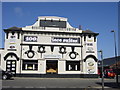
The Bedford Cinema, Bedford Road, Walton.
Liverpool's first purpose built cinema, The Bedford, was built by John Wood, an engineer who toured the country with his mobile cinema. It was opened on Boxing day 1910 and though externally it has changed very little, it now houses a furniture showroom.
The Bedford was demolished in May 2008.
Image: © Sue Adair
Taken: 13 Apr 2006
0.16 miles
5
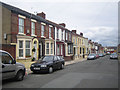
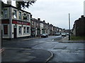
Liverpool: Helena Street, L9
Neat well maintained terraced housing in the Walton area of Liverpool.
Image: © Nigel Cox
Taken: 16 Jun 2007
0.17 miles
6
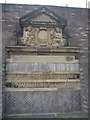
Remains of Walton-on-the-Hill Town Hall
The ancient parish of Walton-on-the-Hill was swallowed up by Liverpool in 1895. You can still see the stone pediment of Walton Town Hall preserved opposite Walton-on-the-Hill church near its original site at the junction of County Road with Queens Drive.
Image: © Sue Adair
Taken: 14 Mar 2007
0.17 miles
9
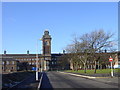
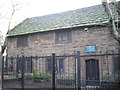
Walton workhouse, Rice Lane
In 1864-9, a new workhouse was built on Rice Lane at Walton-on-the-Hill to serve the northern part of the West Derby Union. It was designed by William Culshaw who was also the architect of the nearby Toxteth Park workhouse. The Walton workhouse initially accommodated 1,200 inmates and its construction cost £65,000. It gradually expanded and by 1930 could hold up to 2,500. The main building was a long three-storey T-shaped block with males accommodated at the east and females at the west. The workhouse later became Walton Institution and then Walton Hospital until its closure in the late 1990s.
Image: © Sue Adair
Taken: 14 Jan 2006
0.21 miles