IMAGES TAKEN NEAR TO
Kirkburn Close, LIVERPOOL, L8 9YA
Introduction
This page details the photographs taken nearby to Kirkburn Close, L8 9YA by members of the Geograph project.
The Geograph project started in 2005 with the aim of publishing, organising and preserving representative images for every square kilometre of Great Britain, Ireland and the Isle of Man.

There are currently over 7.5m images from over14,400 individuals and you can help contribute to the project by visiting https://www.geograph.org.uk
Image Map
Images are licensed for reuse under creativecommons.org/licenses/by-sa/2.0
Notes
- Clicking on the map will re-center to the selected point.
- The higher the marker number, the further away the image location is from the centre of the postcode.
Image Listing (12 Images Found)
Images are licensed for reuse under creativecommons.org/licenses/by-sa/2.0
Image
Details
Distance
5
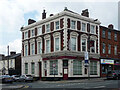
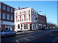
The Pineapple Hotel, Park Road, Liverpool
Solid Italianate boozer on the corner of Moses Street.
The pub may already have closed when this photo was taken - a sign read "Public bar open as usual", but it didn't look open. It continued as a hotel, but has now probably been converted to flats.
Image: © Stephen Richards
Taken: 15 Jun 2016
0.18 miles
6
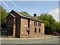
Ancient Chapel of Toxteth
For almost 400 years this little sandstone chapel has stood at the bottom of Park Rd near the junction with Dingle Lane. Toxteth was once a magnificent forest where King John created a Royal park of 2,000 acres where he and his knights could hunt deer and wild boar.
Image: © Sue Adair
Taken: 15 Aug 2005
0.19 miles
7
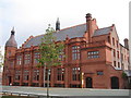
"The Florrie" what a difference!
Seven years on and what a difference http://www.geograph.org.uk/photo/183189.
The spectacular restoration of The Florence Institute has been given recognition by winning a number of prestigious awards including:
RICS National Building Preservation Award 2013
The RIBA North West Award 2013
RIBA North West Conservation Award 2013
RICS North West Building Conservation Award 2013
North West Regional Construction Heritage Award 2013
Civic Trust Award Community Recognition 2013
IHBC North West Award for Conservation 2012
In 2007 after hearing how the community wanted to restore the building Prince Charles personally requested a tour of it and has supported the restoration ever since. Officially re-opened by Prince Charles in January 2013, the building was restored partly by funding of 4.2 million pounds by the Heritage Lottery Fund amongst others.
Image: © Sue Adair
Taken: 5 Sep 2013
0.23 miles
8
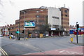
The former Gaumont Cinema, Dingle
It is no longer in use, and it is always difficult to find alternative uses for buildings such as this. It is a significant local landmark.
Image: © Bill Boaden
Taken: 23 Mar 2019
0.24 miles
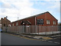
9
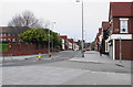
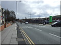
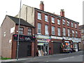
Dingle Lane
The centre of Dingle where there is a handful of shops.
Image: © Bill Boaden
Taken: 23 Mar 2019
0.24 miles
10
The Sailors' Chapel
The Sailors' Chapel is situated on the corner of Beresford Road and Cockburn Street. Liverpool has a long tradition of sailors’ chapels and churches and they almost always had a band and were active in the local community. There was previously a sailors' chapel at the lower end of Wellington Road (renamed Herculaneum Road when new housing was built) and this building replaced that original tin chapel.
Here is a photograph: http://streetsofliverpool.co.uk/wellington-road-1964/
Image: © Sue Adair
Taken: 10 Nov 2012
0.24 miles