1
The Sailors' Chapel
The Sailors' Chapel is situated on the corner of Beresford Road and Cockburn Street. Liverpool has a long tradition of sailors’ chapels and churches and they almost always had a band and were active in the local community. There was previously a sailors' chapel at the lower end of Wellington Road (renamed Herculaneum Road when new housing was built) and this building replaced that original tin chapel.
Here is a photograph: http://streetsofliverpool.co.uk/wellington-road-1964/
Image: © Sue Adair
Taken: 10 Nov 2012
0.01 miles
2
Former pub, Beresford Road, Liverpool
This was the Beresford Arms, "known locally as The Nutty".
Be prepared to pine for it, it has since cashewed in its chips, been wiped off the face of the earth and replaced by a block of flats.
Image: © Stephen Richards
Taken: 15 Jun 2016
0.02 miles
3
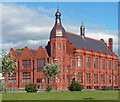
The Florence Institute, Mill Street
The Florence Institute, Mill Street was built by Sir Bernard Hall, (1812-1890), a West Indies merchant, Alderman and former Mayor of Liverpool (1879/80). His daughter, Florence, died tragically at the age of 22 and her father built this boy’s club as a memorial to her, at his sole expense, as a focal point for the local youth who lived in the tough dock-side area of Liverpool. Opening in 1890, for a hundred years "The Florrie" as it is affectionately known by locals, served the young working and unemployed youth of the area, giving them a centre for recreation, opening in 1890 but now, sadly, just a shell despite pleas for funding by "The Friends of the Florrie". More info: http://www.24hourmuseum.org.uk/liverpool/local/TRA24611.htm
Image: © Sue Adair
Taken: 5 Jun 2006
0.10 miles
4
Liverpool Overhead Railway Southern Extension Tunnel
Built in 1896, the tunnel may be unique in that it was built as an overhead railway tunnel. It is now used as a garage, and has been disused as part of a railway since the railway's closure in 1956. Viewed from the roundabout which joins Sefton Street with Riverside Drive.
Image: © El Pollock
Taken: 2 Aug 2012
0.11 miles
5
Dingle Tunnel, Grafton Street, Liverpool
A notable relic of the southern extension of the Liverpool Overhead Railway, opened 1896 and closed in 1956. Grade II listed.
There is much more information here:
Image
The houses above are on Grafton Street.
Image: © Stephen Richards
Taken: 10 Jun 2013
0.12 miles
6
Riverside apartments/Modern art
Newly built riverside apartments on the site of the old Harrington Dock, modern art and to the right the entrance to one of the most exclusive chinese restaurants on Merseyside offering tables with a view of the river and mountains of North Wales.
Image: © Sue Adair
Taken: 19 Mar 2003
0.12 miles
7
"The Florrie" what a difference!
Seven years on and what a difference http://www.geograph.org.uk/photo/183189.
The spectacular restoration of The Florence Institute has been given recognition by winning a number of prestigious awards including:
RICS National Building Preservation Award 2013
The RIBA North West Award 2013
RIBA North West Conservation Award 2013
RICS North West Building Conservation Award 2013
North West Regional Construction Heritage Award 2013
Civic Trust Award Community Recognition 2013
IHBC North West Award for Conservation 2012
In 2007 after hearing how the community wanted to restore the building Prince Charles personally requested a tour of it and has supported the restoration ever since. Officially re-opened by Prince Charles in January 2013, the building was restored partly by funding of 4.2 million pounds by the Heritage Lottery Fund amongst others.
Image: © Sue Adair
Taken: 5 Sep 2013
0.13 miles
8
Former institute, Mill Street, Liverpool
Eat your heart out Alfred Waterhouse, this is possibly the reddest building in the country. The work of H.W. Keef, 1889. Brick and terracotta (
Image]), the corner marked by a polygonal turret. Grade II listed.
Built as the Florence Institute for Boys, for the recreation and education of poor working boys, not very long ago it was ruinous (
Image]). Since restored, it has re-opened as a community centre, The Florrie.
Image: © Stephen Richards
Taken: 14 Aug 2016
0.14 miles
9
Detail of former institute, Mill Street, Liverpool
Sumptuous terracotta decoration to the entrance to this building:
Image
Image: © Stephen Richards
Taken: 15 Jun 2016
0.14 miles
10
Brunswick Business Park and Gasometer on Grafton Street
Brunswick Business Park has developed over the past 20 years, especially popular with car showrooms. Building of new swish apartments with wonderful river views and quick access to the city centre via the new station has really made this old dock area a popular place to live.
Image: © Sue Adair
Taken: 19 Mar 2003
0.16 miles


