IMAGES TAKEN NEAR TO
Byles Street, LIVERPOOL, L8 4PN
Introduction
This page details the photographs taken nearby to Byles Street, L8 4PN by members of the Geograph project.
The Geograph project started in 2005 with the aim of publishing, organising and preserving representative images for every square kilometre of Great Britain, Ireland and the Isle of Man.

There are currently over 7.5m images from over14,400 individuals and you can help contribute to the project by visiting https://www.geograph.org.uk
Image Map
Images are licensed for reuse under creativecommons.org/licenses/by-sa/2.0
Notes
- Clicking on the map will re-center to the selected point.
- The higher the marker number, the further away the image location is from the centre of the postcode.
Image Listing (50 Images Found)
Images are licensed for reuse under creativecommons.org/licenses/by-sa/2.0
Image
Details
Distance
1
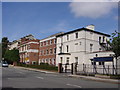
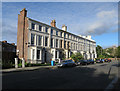
The Belvedere School, Belvidere Road
Founded in 1880, The Belvedere School is an independent school for girls. It is one of the twenty-five schools of the Girls' Day School Trust, which has, since its foundation in 1872, provided a high quality education for girls. Early pupils were among the first women to go to university and enter the professions. As pupil numbers increased neighbouring houses were acquired until it consisted of four converted houses (many original features are still retained) but a purpose built classroom block was added in the 1960's and more recently a fully equipped sports hall.
Image: © Sue Adair
Taken: 15 Aug 2005
0.06 miles
9
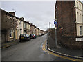
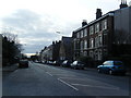
South Street, Toxteth
South Street borders the east side of the Welsh Streets area of Toxteth, and Devonshire Road West is on the right. South Street is due for demolition in phase 3 of the Princes Park regeneration zone project.
Image: © John S Turner
Taken: 6 Jan 2011
0.14 miles