IMAGES TAKEN NEAR TO
Wellesley Road, LIVERPOOL, L8 3SU
Introduction
This page details the photographs taken nearby to Wellesley Road, L8 3SU by members of the Geograph project.
The Geograph project started in 2005 with the aim of publishing, organising and preserving representative images for every square kilometre of Great Britain, Ireland and the Isle of Man.

There are currently over 7.5m images from over14,400 individuals and you can help contribute to the project by visiting https://www.geograph.org.uk
Image Map (Loading...)


Getting Data...Please wait
Leaflet Map data © OpenStreetMap
Images are licensed for reuse under creativecommons.org/licenses/by-sa/2.0
Notes
- Clicking on the map will re-center to the selected point.
- The higher the marker number, the further away the image location is from the centre of the postcode.
Image Listing (17 Images Found)
Images are licensed for reuse under creativecommons.org/licenses/by-sa/2.0
Image
Details
Distance
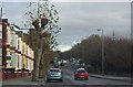
1
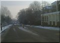
Entrance to Prince's Park from Belvidere road
Image: © Raymond Knapman
Taken: 19 Nov 2010
0.05 miles
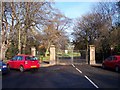
5
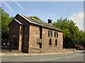
Ancient Chapel of Toxteth
For almost 400 years this little sandstone chapel has stood at the bottom of Park Rd near the junction with Dingle Lane. Toxteth was once a magnificent forest where King John created a Royal park of 2,000 acres where he and his knights could hunt deer and wild boar.
Image: © Sue Adair
Taken: 15 Aug 2005
0.13 miles
6
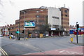
Road works on Park Road
The old Gaumont cinema stands lifeless in background
Image: © Raymond Knapman
Taken: 19 Nov 2010
0.14 miles
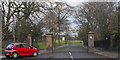
7
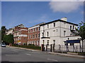
The Belvedere School, Belvidere Road
Founded in 1880, The Belvedere School is an independent school for girls. It is one of the twenty-five schools of the Girls' Day School Trust, which has, since its foundation in 1872, provided a high quality education for girls. Early pupils were among the first women to go to university and enter the professions. As pupil numbers increased neighbouring houses were acquired until it consisted of four converted houses (many original features are still retained) but a purpose built classroom block was added in the 1960's and more recently a fully equipped sports hall.
Image: © Sue Adair
Taken: 15 Aug 2005
0.15 miles
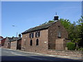
8
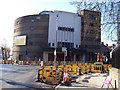
The former Gaumont Cinema, Dingle
It is no longer in use, and it is always difficult to find alternative uses for buildings such as this. It is a significant local landmark.
Image: © Bill Boaden
Taken: 23 Mar 2019
0.15 miles
9
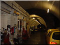
Dingle Station, Overhead Railway
Dingle station on a branchline of the Overhead Railway opened on 21/12/1896 and was closed 30/12/1956, the overhead structure of the railway being dismantled soon after but leaving behind this one station which although the platforms have been demolished, the ticket office and half mile of tunnel still exists today. The Overhead belied its name at this southern terminus, passengers new to Dingle no doubt wondering why they had to descend steps and a subway to gain the platforms of an elevated railway.
Image: © Sue Adair
Taken: 15 Aug 2005
0.17 miles