IMAGES TAKEN NEAR TO
Ullet Road, LIVERPOOL, L8 3SP
Introduction
This page details the photographs taken nearby to Ullet Road, L8 3SP by members of the Geograph project.
The Geograph project started in 2005 with the aim of publishing, organising and preserving representative images for every square kilometre of Great Britain, Ireland and the Isle of Man.

There are currently over 7.5m images from over14,400 individuals and you can help contribute to the project by visiting https://www.geograph.org.uk
Image Map (Loading...)


Getting Data...Please wait
Leaflet Map data © OpenStreetMap
Images are licensed for reuse under creativecommons.org/licenses/by-sa/2.0
Notes
- Clicking on the map will re-center to the selected point.
- The higher the marker number, the further away the image location is from the centre of the postcode.
Image Listing (80 Images Found)
Images are licensed for reuse under creativecommons.org/licenses/by-sa/2.0
Image
Details
Distance
1
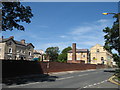
Bellerive School, Ullet Road
Bellerive School in Ullet Road which now goes by the name of Bellerive FCJ Catholic College. The original convent in Windermere Terrace was built in 1844.
Image: © Sue Adair
Taken: 31 Jul 2007
0.01 miles
2
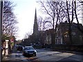
Linnet Lane
The spire of Christ Church prominent
Image: © Raymond Knapman
Taken: 19 Nov 2010
0.03 miles
4
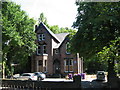
28 Ullet Road, John Brodie's House
John Brodie, best known as the designer of the Mersey Tunnel, was also a town planner and the inventor of the goal net. First used in a football match in 1890 in a game between Nottingham Forest and Bolton Wanderers, it proved an instant success. Brodie served as Liverpool's City Engineer 1898-1926 making several proposals for the improvement of the city's roads, including the construction of an inner ring road - Queen's Drive. He also patented the idea of prefabricating houses from reinforced concrete slabs and introduced the idea of using central reservations for tramcars. The first reserved track, Edge Lane to Broad Green, was completed in 1914 and was followed by many others. We have him to thank for the many wide, tree-lined avenues in Liverpool's suburbs, one of these, Brodie Avenue, is named after him.
Image: © Sue Adair
Taken: 31 Jul 2007
0.06 miles
5
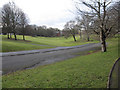
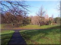
Prince's Park view towards Glade Park Court
Looking a shallow landscaped valley in Prince's Park with the modern development, Glade Park Court, at the end of the view.
Image: © John S Turner
Taken: 16 Feb 2010
0.06 miles
6

Petrol station on Ullet Road
Viewed from the edge of Princes Park. The petrol station has a convenience store which is open 24 hours.
Image: © Bill Boaden
Taken: 23 Mar 2019
0.06 miles
7
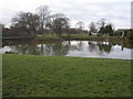
Prince's Park Lake
Looking across the south-east corner of Prince's Park lake. On the right are the remains of the boathouse, which burnt down in the 1990s.
Image: © John S Turner
Taken: 16 Feb 2010
0.06 miles
8
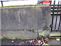
Bench mark outside #5 Windermere Terrace, Prince's Park
This bench mark is on the low stone wall in front of #5 Windermere Terrace, Prince's Park.
Image: © John S Turner
Taken: 16 Feb 2010
0.07 miles
9
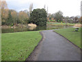
Prince's Park and lake
Looking along the lakeside path in Prince's Park.
Image: © John S Turner
Taken: 16 Feb 2010
0.07 miles
10

The south-west corner of Prince's Park lake
Looking across the south-west corner of Prince's Park lake with Princes Park Mansions behind the tree on the right.
Image: © John S Turner
Taken: 16 Feb 2010
0.08 miles