IMAGES TAKEN NEAR TO
Binns Road, LIVERPOOL, L7 9NE
Introduction
This page details the photographs taken nearby to Binns Road, L7 9NE by members of the Geograph project.
The Geograph project started in 2005 with the aim of publishing, organising and preserving representative images for every square kilometre of Great Britain, Ireland and the Isle of Man.

There are currently over 7.5m images from over14,400 individuals and you can help contribute to the project by visiting https://www.geograph.org.uk
Image Map
Images are licensed for reuse under creativecommons.org/licenses/by-sa/2.0
Notes
- Clicking on the map will re-center to the selected point.
- The higher the marker number, the further away the image location is from the centre of the postcode.
Image Listing (36 Images Found)
Images are licensed for reuse under creativecommons.org/licenses/by-sa/2.0
Image
Details
Distance
1
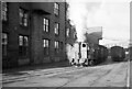
Fireless loco at Crawford's biscuit factory ? 1965 - 1
Bringing wagons out from the factory yard onto British Rail sidings.
Image: © Alan Murray-Rust
Taken: 24 Nov 1965
0.02 miles
2
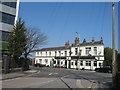
The Railway, Binns Road
This old pub no longer has any "locals", it is surrounded by factories, warehouses and units of the Edge Lane retail and Wavertree Technology Park.
Image: © Sue Adair
Taken: 1 Apr 2007
0.04 miles
3

Fireless loco at Crawford's biscuit factory ? 1965 - 2
Bringing wagons out of the factory yard onto British Railways sidings.
Image: © Alan Murray-Rust
Taken: 24 Nov 1965
0.06 miles
4

On charge ? 1965
The loco is seen here connected by means of a flexible pipe to the main high pressure supply.
Image: © Alan Murray-Rust
Taken: 7 Nov 1965
0.08 miles
6

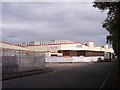
Rathbone Building, Dryden Road, Liverpool
The curved end and bands of windows suggest the 1930s. Is it a homage?
It sits in Liverpool Innovation Park, a business park for those in "the science, information, communications and knowledge-based sectors."
Image: © Stephen Richards
Taken: 27 Jul 2011
0.08 miles
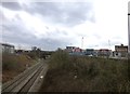
7
The Bootle Branch railway is joined by the reinstated chord from Olive Mount Cutting
Image: © Raymond Knapman
Taken: 20 Sep 2010
0.09 miles

9

Liverpool Shopping Park (1)
A recently opened retail park just off Edge Lane, conveniently situated for out-of-town visitors coming off the M62 a mile away. It was built on the site of several former factories including the Meccano works.
Like most such commercial developments, all the shops are "big name" chain stores rather than local independents. Shops in this view include River Island, Next, JD Sports and Outfit.
Image: © Stephen Craven
Taken: 29 Dec 2017
0.10 miles
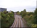
10
The Bootle Branch Line viewed from Edge Lane bridge
The freight railway line from Bootle Docks to Edge Hill passing by Wavertree Technology Park
Image: © Raymond Knapman
Taken: 18 Feb 2014
0.10 miles