IMAGES TAKEN NEAR TO
Prescot Street, LIVERPOOL, L7 8UL
Introduction
This page details the photographs taken nearby to Prescot Street, L7 8UL by members of the Geograph project.
The Geograph project started in 2005 with the aim of publishing, organising and preserving representative images for every square kilometre of Great Britain, Ireland and the Isle of Man.

There are currently over 7.5m images from over14,400 individuals and you can help contribute to the project by visiting https://www.geograph.org.uk
Image Map (Loading...)


Getting Data...Please wait
Leaflet Map data © OpenStreetMap
Images are licensed for reuse under creativecommons.org/licenses/by-sa/2.0
Notes
- Clicking on the map will re-center to the selected point.
- The higher the marker number, the further away the image location is from the centre of the postcode.
Image Listing (46 Images Found)
Images are licensed for reuse under creativecommons.org/licenses/by-sa/2.0
Image
Details
Distance
1
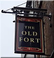
Sign for the Old Fort public house, Liverpool
Image: © JThomas
Taken: 28 Apr 2019
0.05 miles
2

The Old Fort public house, Liverpool
On Prescot Street.
Image: © JThomas
Taken: 28 Apr 2019
0.05 miles
3
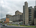
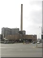
Royal Liverpool University Hospital, Prescot Street, Liverpool (2)
A mighty palace of concrete. Planned from 1963-65 and opened in 1978. The architects were Holford Associates. Behind the long grid are clinical departments, the higher projecting sections behind house teaching blocks. Nearer the camera is a stair tower.
The hospital has more than 700 beds, the largest in the area by some distance, and its Emergency Department is supposedly the largest in the country. Unfathomably, not everyone appreciates concrete and a plan to demolish the current buildings is making headway.
The other side: Image
Image: © Stephen Richards
Taken: 27 Jul 2011
0.06 miles
4
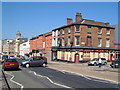
The Old Fort, Prescot Street, Liverpool
The north side of Prescot street, with The Old Fort pub on the corner of Moira Street; taken from in front of University Hospital.
Image: © Derek Harper
Taken: 17 Jul 2006
0.06 miles
5
Royal Liverpool University Hospital
The hospital straddles a gridline; the parts of the structures shown (eastern part of the site) are in SJ3690. Seen across Prescot Street.
Image: © Derek Harper
Taken: 17 Jul 2006
0.07 miles
6
The Royal Liverpool University Hospital
Looking across a wide road junction towards part of the Royal Liverpool University Hospital site. On completion of the new hospital on adjacent land the old buildings visible here will be demolished.
Image: © Graham Robson
Taken: 13 Mar 2016
0.08 miles
7
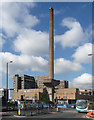
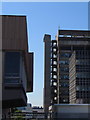
Boiler House, Prescot Street, Liverpool
A piece of 1960s Brutalism belonging to the Royal Liverpool University Hospital (visible behind). Pevsner remarks that the chimney resembles "a giant upended hammer".
Image: © Stephen Richards
Taken: 26 Jul 2011
0.08 miles
8
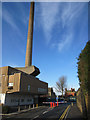
Royal Liverpool University Hospital chimney
Looking along what used to be Mount Vernon Street towards Prescot Street, Kensington. The street now provides access to the Royal Liverpool University Hospital car park. On the left is the hospital chimney, which can be seen from many parts of the city. Out of sight on the right is the Sacred Heart RC church.
Image: © John S Turner
Taken: 28 Jan 2012
0.09 miles
9
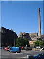
Junction beside Sacred Heart church, Liverpool
The church http://list.english-heritage.org.uk/resultsingle.aspx?uid=1252909&searchtype=mapsearch is shown in Image On the right is Royal Liverpool University Hospital, and the chimney shown in Image in a more vertical pose.
Image: © Derek Harper
Taken: 17 Jul 2006
0.10 miles
10
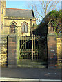
Side gate to the Sacred Heart RC church
This locked side gate is alongside what used to be Mount Vernon Road. The road is now the access to the Royal Liverpool University Hospital car park.
Image: © John S Turner
Taken: 28 Jan 2012
0.11 miles