IMAGES TAKEN NEAR TO
Earle Road, LIVERPOOL, L7 6HH
Introduction
This page details the photographs taken nearby to Earle Road, L7 6HH by members of the Geograph project.
The Geograph project started in 2005 with the aim of publishing, organising and preserving representative images for every square kilometre of Great Britain, Ireland and the Isle of Man.

There are currently over 7.5m images from over14,400 individuals and you can help contribute to the project by visiting https://www.geograph.org.uk
Image Map
Images are licensed for reuse under creativecommons.org/licenses/by-sa/2.0
Notes
- Clicking on the map will re-center to the selected point.
- The higher the marker number, the further away the image location is from the centre of the postcode.
Image Listing (31 Images Found)
Images are licensed for reuse under creativecommons.org/licenses/by-sa/2.0
Image
Details
Distance
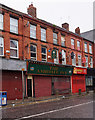
1
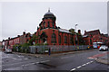
Church of the Protestant Martyrs
On Salisbury Road at Lawrence Road, Liverpool.
Image: © Ian S
Taken: 12 Jun 2019
0.08 miles
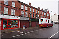
2

Tunstall Street, Liverpool
Sadly, an all too common a sight in northern England (and quite possibly the Midlands, Scotland and Wales). Satellite imagery shows ranks of tightly-packed streets (apparently packed with people), including where I was standing, so they have gone fairly recently. I don't understand the economics or the logic, if there is any, of demolishing houses like this.
Image: © Stephen Richards
Taken: 26 Jul 2011
0.09 miles

5
Church of the Protestant Martyrs
On Salisbury Road at Lawrence Road, Liverpool.
Image: © Ian S
Taken: 12 Jun 2019
0.09 miles
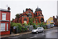
6
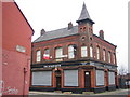
Liverpool: The Spofforth Public House, Edge Hill, L7
This pub is on Spofforth Road at its junction with Cadogan Street and Spekeland Road. The road and pub are named after Fred Spofforth, an Australian cricketer of the 1870s and 1880s who was known as "The Demon Bowler" in recognition of his achievements.
Image: © Nigel Cox
Taken: 19 Feb 2007
0.10 miles
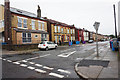
7
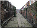
Ennog, Liverpool 15
Typical back lane or entry running behind a terraced street in Wavertree. Some are much messier than this one.
Image: © Cathy Cox
Taken: 20 Feb 2008
0.10 miles
8
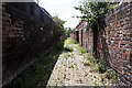
Ennog, Liverpool 15 revisited
This is the same view as Image photographed over three years later. The ends of the alleyway are blocked with keys held only by residents requiring access and the local council is no longer applying weedkiller. Nature is taking over with abundant growths of buddleia, ragwort (with a rampant population of cinnabar moth caterpillars), herb robert, various hawkweeds, willowherbs and sun spurge to mention a few.
Image: © Cathy Cox
Taken: 25 Jul 2011
0.10 miles