IMAGES TAKEN NEAR TO
Alexandra Road, LIVERPOOL, L7 6AU
Introduction
This page details the photographs taken nearby to Alexandra Road, L7 6AU by members of the Geograph project.
The Geograph project started in 2005 with the aim of publishing, organising and preserving representative images for every square kilometre of Great Britain, Ireland and the Isle of Man.

There are currently over 7.5m images from over14,400 individuals and you can help contribute to the project by visiting https://www.geograph.org.uk
Image Map
Images are licensed for reuse under creativecommons.org/licenses/by-sa/2.0
Notes
- Clicking on the map will re-center to the selected point.
- The higher the marker number, the further away the image location is from the centre of the postcode.
Image Listing (49 Images Found)
Images are licensed for reuse under creativecommons.org/licenses/by-sa/2.0
Image
Details
Distance
1
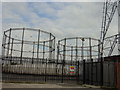
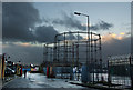
Gasometers, Webster Road
Gasworks on Webster Road near Picton Road
Image: © Sue Adair
Taken: 16 Aug 2005
0.04 miles
2
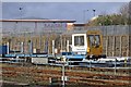
Balfour Beatty maintenance vehicle, DR98215, Edge Hill sidings
Viewed from a train to the east of the station.
Image: © El Pollock
Taken: 17 Jan 2014
0.09 miles
4
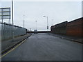
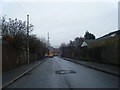
Spofforth Road looking towards Picton Road.
Image: © Colin Pyle
Taken: 22 Jan 2010
0.10 miles
5
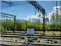
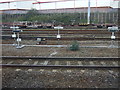
Overhead Gantries and Gas Holder near Edge Hill Station
Image: © David Dixon
Taken: 27 Apr 2015
0.10 miles

8
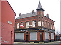
Liverpool: The Spofforth Public House, Edge Hill, L7
This pub is on Spofforth Road at its junction with Cadogan Street and Spekeland Road. The road and pub are named after Fred Spofforth, an Australian cricketer of the 1870s and 1880s who was known as "The Demon Bowler" in recognition of his achievements.
Image: © Nigel Cox
Taken: 19 Feb 2007
0.14 miles
9
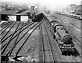
London express pulling away from Edge Hill, Liverpool
View westward from Picton Road bridge, towards Edge Hill and Lime Street stations, ex-LNW main lines from Crewe and from Manchester, flanked by the lines to Wapping Goods to the left and Waterloo Goods to the right. The 11.05 express to Euston is on the Up Fast line, headed by Stanier 'Jubilee' 6P 4-6-0 No. 45681 'Aboukir' (built 12/35, withdrawn 9/64). On the left are the Edge Hill Down Sidings, Spekeland Road Goods and the Carriage Depot, also the lines to Wapping: on the right are the lines to Waterloo and the sidings serving the Edge Hill Goods Depot and Fruit & Vegetable Market. The signalbox in the middle distance is Edge Hill No. 2. Behind the camera is the great complex of Edge Hill Sorting Sidings and its junctions. (See also Image...)
Image: © Ben Brooksbank
Taken: 12 Jun 1959
0.15 miles