IMAGES TAKEN NEAR TO
Old College Place, LIVERPOOL, L7 5DA
Introduction
This page details the photographs taken nearby to Old College Place, L7 5DA by members of the Geograph project.
The Geograph project started in 2005 with the aim of publishing, organising and preserving representative images for every square kilometre of Great Britain, Ireland and the Isle of Man.

There are currently over 7.5m images from over14,400 individuals and you can help contribute to the project by visiting https://www.geograph.org.uk
Image Map
Images are licensed for reuse under creativecommons.org/licenses/by-sa/2.0
Notes
- Clicking on the map will re-center to the selected point.
- The higher the marker number, the further away the image location is from the centre of the postcode.
Image Listing (48 Images Found)
Images are licensed for reuse under creativecommons.org/licenses/by-sa/2.0
Image
Details
Distance
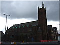
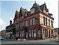
1
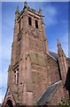
St Cyprian's church, Edge Hill
Architects Culshaw & Sumners, 1881.
Image: © S Parish
Taken: 3 Mar 2006
0.02 miles
2
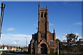
St Cyprian's Church, Liverpool
No longer in use, but plans are being considered to incorporate the building in new schemes.
Image: © Bill Boaden
Taken: 19 Oct 2013
0.07 miles
4
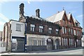
Durning Road (Liverpool) old fire & police station
Durning Road old fire & police station and The Shipperies pub, now standing forlorn with all the properties around having been demolished
Image: © Kevin Hale
Taken: 27 May 2010
0.09 miles
5
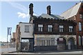
Durning Road old fire & police station
Durning Road old fire & police station, Durning Road, Liverpool
Image: © Kevin Hale
Taken: 27 May 2010
0.09 miles
6
Former pub, Durning Road, Liverpool
Latterly the Shipperies, its windows filled with metal shutters and bedevilled by fly posters at the time. The adjacent former police/fire station was also derelict.
Both have since been restored as flats.
Image: © Stephen Richards
Taken: 9 Jun 2013
0.09 miles
7
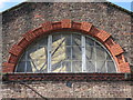
Kensington drill hall window
This window is high up above the carriage entrance to the former Kensington drill hall in Botanic Road. The large hall, which was built around 1900 for the 4th West Lancashire Howitzer Brigade, Royal Field Artillery (7th and 8th Howitzer Batteries), has two gable ends and two curved windows facing Botanic Road. These large windows help to light the open space inside, and part of the roof structure can be seen through the window. See also Image
Image: © John S Turner
Taken: 2 Sep 2014
0.10 miles
8
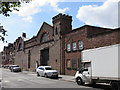
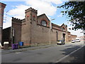
Kensington Drill Hall (former) (1)
Looking across Botanic Road towards the drill hall for 4th West Lancashire Howitzer Brigade, Royal Field Artillery (7th and 8th Howitzer Batteries). The drill hall was built around 1900 on the large garden plot behind a sandstone farmhouse called The Grange, which I assume was used by the officers.
The large opening would have always existed for access to the hall, but it seems to have been heightened in more recent times as the obvious girder, and poor brickwork repairs higher up, contrast badly with the original fine Victorian brickwork.
Image: © John S Turner
Taken: 2 Sep 2014
0.10 miles
10
Kensington Drill Hall (former) (2)
Looking across Botanic Road towards the south east corner of the drill hall for 4th West Lancashire Howitzer Brigade, Royal Field Artillery (7th and 8th Howitzer Batteries). The drill hall was built around 1900 on the large garden plot behind a sandstone farmhouse called The Grange, which faced onto Edge Lane. In this view the stylish Victorian frontage can be seen disguising the plainer structure of the functional hall behind.
Image: © John S Turner
Taken: 2 Sep 2014
0.10 miles