IMAGES TAKEN NEAR TO
Corney Street, LIVERPOOL, L7 4JP
Introduction
This page details the photographs taken nearby to Corney Street, L7 4JP by members of the Geograph project.
The Geograph project started in 2005 with the aim of publishing, organising and preserving representative images for every square kilometre of Great Britain, Ireland and the Isle of Man.

There are currently over 7.5m images from over14,400 individuals and you can help contribute to the project by visiting https://www.geograph.org.uk
Image Map
Images are licensed for reuse under creativecommons.org/licenses/by-sa/2.0
Notes
- Clicking on the map will re-center to the selected point.
- The higher the marker number, the further away the image location is from the centre of the postcode.
Image Listing (18 Images Found)
Images are licensed for reuse under creativecommons.org/licenses/by-sa/2.0
Image
Details
Distance
1
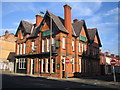
Toxteth, Newstead Abbey
Victorian corner pub on Smithdown and Newstead Roads. Internally, some original features, two levels, TV, games machine, darts; no cask ale available.
Image: © Mike Faherty
Taken: 4 Aug 2015
0.06 miles
2
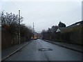
Liverpool: Mulliner Street, Edge Hill, L7
Mulliner Street is one of four streets (the others are Scholar, Underley and Cantsfield) that are threatened with demolition as part of the Picton Redevelopment scheme. Most houses in the street are bricked up, but a few residents remain to resist the proposals. They have a website here http://www.indymedia.org.uk/en/regions/liverpool/2006/06/343179.html
Image: © Nigel Cox
Taken: 18 Feb 2007
0.07 miles
3
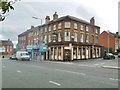
Liverpool: The Mulliner Public House, Edge Hill, L7
One of the hostelries on the infamous Smithdown Ten pub crawl, beloved by Liverpool University students since time immemorial, and located, unsurprisingly, on the north side of Smithdown at the junction with Mulliner Street.
Image: © Nigel Cox
Taken: 18 Feb 2007
0.09 miles
4

St Dunstan's Church, Edge Hill
Viewed across an area of cleared terraced housing.
Image: © Bill Boaden
Taken: 19 Oct 2013
0.10 miles
5
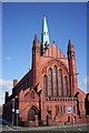
St Dunstan, Edge Hill
Architects Aldridge & Deacon, 1889.
Image: © S Parish
Taken: 3 Mar 2006
0.12 miles

7

Former bank on Smithdown Road
It sits in the sharp angle between Smithdown Road and Earle Road. I think this was once a District Bank (constituent of NatWest) but can't be sure. It is now available for rent.
Image: © Bill Boaden
Taken: 19 Oct 2013
0.14 miles
8

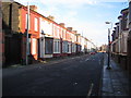
Toxteth, terraced housing
On Noel Street, L8.
Image: © Mike Faherty
Taken: 4 Aug 2015
0.15 miles
9

Tunstall Street, Liverpool
Sadly, an all too common a sight in northern England (and quite possibly the Midlands, Scotland and Wales). Satellite imagery shows ranks of tightly-packed streets (apparently packed with people), including where I was standing, so they have gone fairly recently. I don't understand the economics or the logic, if there is any, of demolishing houses like this.
Image: © Stephen Richards
Taken: 26 Jul 2011
0.16 miles