IMAGES TAKEN NEAR TO
Sirdar Close, LIVERPOOL, L7 3QN
Introduction
This page details the photographs taken nearby to Sirdar Close, L7 3QN by members of the Geograph project.
The Geograph project started in 2005 with the aim of publishing, organising and preserving representative images for every square kilometre of Great Britain, Ireland and the Isle of Man.

There are currently over 7.5m images from over14,400 individuals and you can help contribute to the project by visiting https://www.geograph.org.uk
Image Map (37 Images)


Getting Data...Please wait
Leaflet Map data © OpenStreetMap
Images are licensed for reuse under creativecommons.org/licenses/by-sa/2.0
Notes
- Clicking on the map will re-center to the selected point.
- The higher the marker number, the further away the image location is from the centre of the postcode.
Image Listing (37 Images Found)
Images are licensed for reuse under creativecommons.org/licenses/by-sa/2.0
Image
Details
Distance
1
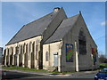
St Catherine's Church, Tunnel Road
The former St Catherine's Church, Tunnel Road, Edge Hill used, amongst other things as a jujitsu club until 2007. The foundation stone was laid July 5th 1862 and it opened May 21st 1863.
Demolished in February 2008
Image: © Sue Adair
Taken: 8 Mar 2007
0.09 miles
2
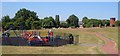
Playground, Overbury Street, Liverpool
Liverpool City Council calls this Crown Street playground but it's the far side of the park from there (seen in the background, with the Anglican Cathedral above). To the right is Image
Image: © Derek Harper
Taken: 17 Jul 2006
0.09 miles
3
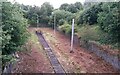
Crown Street station, last remnant
Crown Street station was one of the first two railway stations in the world, along with Liverpool Road station, Manchester, which survives. Crown Street was superseded by Lime Street station in Liverpool in 1836 but became a goods depot. Until the reinstatement of the Olive Mount Chord in 2008, an old tunnel to Crown Street was used as sidings where locomotives could "run round" a train to reverse it. The picture shows the head of the siding (two lines enter the tunnel and join in the tunnel). An earlier view, from the opposite direction, with 25kV wires still in place, is at https://www.geograph.org.uk/photo/64494 .
Historic detail at www.gracesguide.co.uk/Crown_Street_Tunnel
Image: © S Parish
Taken: 30 Jul 2015
0.10 miles
4
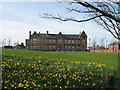
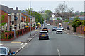
Smithdown Primary School
Smithdown Primary School from Tunnel Road.
Image: © Sue Adair
Taken: 8 Mar 2007
0.11 miles
5
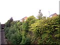
Shrubbery takes over the head-shunt at Edge Hill
This cutting once led to the famous Moorish Arch at the original terminus of the Liverpool and Manchester Railway.
Image: © Raymond Knapman
Taken: 20 Sep 2010
0.11 miles

9
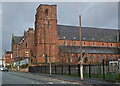
The Church of St. Anne, Overbury Street
St. Anne's mission was begun in Sep 1843 in order to serve the Catholic population of the rapidly expanding Edge Hill area. One of two Benedictine missions in Liverpool, the priest's house was begun in 1841 and Father Maurus Magison said Mass in the house until the church was built. The Church of St. Anne, designed by Charles Hansom, was opened on 4 August 1846.
Image: © Sue Adair
Taken: 1 Apr 2007
0.16 miles
10
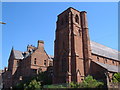
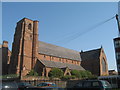
St. Anne's Church, Overbury Street, Liverpool
Another view of the red sandstone Image https://historicengland.org.uk/listing/the-list/list-entry/1072983 , with the Presbytery https://historicengland.org.uk/listing/the-list/list-entry/1072984 on the left.
Image: © Derek Harper
Taken: 17 Jul 2006
0.16 miles