IMAGES TAKEN NEAR TO
Minster Court, LIVERPOOL, L7 3QD
Introduction
This page details the photographs taken nearby to Minster Court, L7 3QD by members of the Geograph project.
The Geograph project started in 2005 with the aim of publishing, organising and preserving representative images for every square kilometre of Great Britain, Ireland and the Isle of Man.

There are currently over 7.5m images from over14,400 individuals and you can help contribute to the project by visiting https://www.geograph.org.uk
Image Map (Loading...)


Getting Data...Please wait
Leaflet Map data © OpenStreetMap
Images are licensed for reuse under creativecommons.org/licenses/by-sa/2.0
Notes
- Clicking on the map will re-center to the selected point.
- The higher the marker number, the further away the image location is from the centre of the postcode.
Image Listing (78 Images Found)
Images are licensed for reuse under creativecommons.org/licenses/by-sa/2.0
Image
Details
Distance
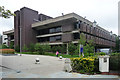
3
Chatham Building extension, University of Liverpool
This extension is mentioned in Image and houses the University's Management School, including its eBusiness Research Centre.
Image: © Derek Harper
Taken: 17 Jul 2006
0.09 miles
4
Sydney Jones Library, Chatham Street, Liverpool
By Basil Spence, Glover & Ferguson, 1976, for the University of Liverpool. Brick and concrete, long and low, its horizontality counterposed by prominent stair towers. The boxy projections contain individual work spaces.
Image: © Stephen Richards
Taken: 28 Jul 2011
0.12 miles
5
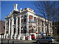
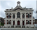
Liverpool: The Chatham Building, University of Liverpool
The Grade II listed Chatham Building in Chatham Street is now the home of the University's School of Management with a £10 million modern extension behind it. The building was originally a chapel dating from 1865. The contrast with other buildings in this grid square such as Image is quite remarkable.
Image: © Nigel Cox
Taken: 18 Feb 2007
0.12 miles
6
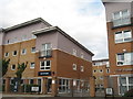
The Railyard & The Sidings
The Railyard and The Sidings at Crown Station Place, student accommodation built on the site of the Agricultural Depot and coal yards of the London, Midland and Scottish Railway in Crown Street.
Image: © Sue Adair
Taken: 24 Aug 2017
0.12 miles
7
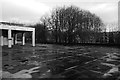
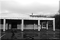
Car park, Brett Building
University of Liverpool.
Image: © Richard Webb
Taken: 26 Dec 2017
0.12 miles
8
Chatham Building, Chatham Street, Liverpool
Not exactly a refined facade, but its exuberance charms. Built 1860-61 by Oliver & Lamb as a Welsh Presbyterian Chapel. Italianate, with giant Corinthian pilasters, pediment and "grotesque" bellcote. Grade II listed.
It is now part of the University of Liverpool.
Image: © Stephen Richards
Taken: 28 Jul 2011
0.12 miles
9
Brett Building
University of Liverpool, refurbished and reopened as an MBA study centre in 2014.
Image: © Richard Webb
Taken: 26 Dec 2017
0.13 miles