IMAGES TAKEN NEAR TO
Woodside Street, LIVERPOOL, L7 3HT
Introduction
This page details the photographs taken nearby to Woodside Street, L7 3HT by members of the Geograph project.
The Geograph project started in 2005 with the aim of publishing, organising and preserving representative images for every square kilometre of Great Britain, Ireland and the Isle of Man.

There are currently over 7.5m images from over14,400 individuals and you can help contribute to the project by visiting https://www.geograph.org.uk
Image Map
Images are licensed for reuse under creativecommons.org/licenses/by-sa/2.0
Notes
- Clicking on the map will re-center to the selected point.
- The higher the marker number, the further away the image location is from the centre of the postcode.
Image Listing (46 Images Found)
Images are licensed for reuse under creativecommons.org/licenses/by-sa/2.0
Image
Details
Distance
2
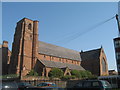
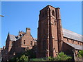
The Church of St. Anne, Overbury Street
St. Anne's mission was begun in Sep 1843 in order to serve the Catholic population of the rapidly expanding Edge Hill area. One of two Benedictine missions in Liverpool, the priest's house was begun in 1841 and Father Maurus Magison said Mass in the house until the church was built. The Church of St. Anne, designed by Charles Hansom, was opened on 4 August 1846.
Image: © Sue Adair
Taken: 1 Apr 2007
0.09 miles
3
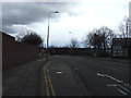
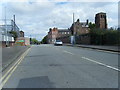
Wavertree Road, Edge Hill
This is the B5178, heading eastwards out of Liverpool, taken from near Image
Image: © Derek Harper
Taken: 17 Jul 2006
0.10 miles
5
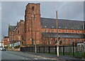
St. Anne's Church, Overbury Street, Liverpool
Another view of the red sandstone Image https://historicengland.org.uk/listing/the-list/list-entry/1072983 , with the Presbytery https://historicengland.org.uk/listing/the-list/list-entry/1072984 on the left.
Image: © Derek Harper
Taken: 17 Jul 2006
0.12 miles
7
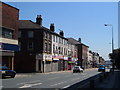
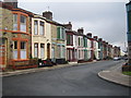
Liverpool: The Grove Public House, Edge Hill, L7
The Grove is a former neighbourhood pub at the western end of Plimsoll Street and at the northern end of Thorburn Street, in an area that is presumably subject to an overall Compulsory Purchase Order by Liverpool City Council. This is taken looking back at the corner of Plimsoll Street where Image was taken from. Most of the houses in the street already have blocked up doors and windows, so this view is not going to last forever...
Image: © Nigel Cox
Taken: 16 Jun 2007
0.13 miles
8
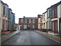
Liverpool: Plimsoll Street, Edge Hill, L7
90% of the Victorian terraced houses in this street are boarded up and vacant, and presumably scheduled for demolition. A few house-proud occupiers hang on though.
Image: © Nigel Cox
Taken: 16 Jun 2007
0.13 miles
10
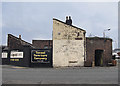
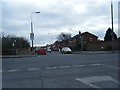
Furniture store
A furniture store near Edge Hill station in Liverpool
Image: © William Starkey
Taken: 14 Mar 2015
0.15 miles