1
Edge Hill Church (St Mary's)
Edge Hill Church or to give it its proper name, St Mary's, is a local landmark. The church was opened in 1813 and holds a prominent position on a sandstone ridge overlooking the city.
Image: © Sue Adair
Taken: 1 Apr 2007
0.04 miles
2
Marmaduke Street, Edge Hill
Image: © Sue Adair
Taken: 1 Apr 2007
0.06 miles
3
The Weighing Machine
The Weighing Machine pub at the junction of Wavertree Road with Marmaduke Street.
Image: © Sue Adair
Taken: 1 Apr 2007
0.06 miles
4
Clare Terrace, Marmaduke Street
Clare Terrace, Marmaduke Street is an elegant row of mansion houses, a wonderful example of this type of architecture.
Image: © Sue Adair
Taken: 1 Apr 2007
0.07 miles
5
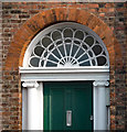
Detail of 4 Edge Lane, Liverpool
Pretty radial fanlight.
Image: © Stephen Richards
Taken: 9 Jun 2013
0.07 miles
6
Clare Terrace, Marmaduke Street, Liverpool
A good early C19th terrace with projecting and pedimented centre and end (the other end has gone), the ground floor with channelled rustication. Grade II listed.
Image: © Stephen Richards
Taken: 9 Jun 2013
0.08 miles
7
The Weighing Machine, Edge Hill
Another view of
Image from the crossroads of Wavertree Road (left) with
Image (right) and Overbury Street (left).
Image: © Derek Harper
Taken: 17 Jul 2006
0.08 miles
8
15-37 Marmaduke Street, Liverpool
Boarded up Victorian houses which, like those in the streets behind, have since been demolished, to be replaced by new housing. Crazy stuff.
Image: © Stephen Richards
Taken: 9 Jun 2013
0.08 miles
9
3-7 North View, Liverpool
Brick nos. 6-7 are three-storey early C19th houses, not quite as refined as those in the Georgian Quarter but still handsome. Grade II listed.
The others, also easy on the eye, must be two or three decades later and are unlisted.
Image: © Stephen Richards
Taken: 9 Jun 2013
0.09 miles
10
Corner Shop, Empress Road - Liverpool
Image: © Anthony Parkes
Taken: 11 Oct 2014
0.09 miles


