IMAGES TAKEN NEAR TO
Janet Drive, LIVERPOOL, L7 1AE
Introduction
This page details the photographs taken nearby to Janet Drive, L7 1AE by members of the Geograph project.
The Geograph project started in 2005 with the aim of publishing, organising and preserving representative images for every square kilometre of Great Britain, Ireland and the Isle of Man.

There are currently over 7.5m images from over14,400 individuals and you can help contribute to the project by visiting https://www.geograph.org.uk
Image Map
Images are licensed for reuse under creativecommons.org/licenses/by-sa/2.0
Notes
- Clicking on the map will re-center to the selected point.
- The higher the marker number, the further away the image location is from the centre of the postcode.
Image Listing (45 Images Found)
Images are licensed for reuse under creativecommons.org/licenses/by-sa/2.0
Image
Details
Distance
1
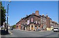
Liverpool: The Grove Public House, Edge Hill, L7
The Grove is a former neighbourhood pub at the western end of Plimsoll Street and at the northern end of Thorburn Street, in an area that is presumably subject to an overall Compulsory Purchase Order by Liverpool City Council. This is taken looking back at the corner of Plimsoll Street where Image was taken from. Most of the houses in the street already have blocked up doors and windows, so this view is not going to last forever...
Image: © Nigel Cox
Taken: 16 Jun 2007
0.06 miles
2
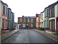
Liverpool: Plimsoll Street, Edge Hill, L7
90% of the Victorian terraced houses in this street are boarded up and vacant, and presumably scheduled for demolition. A few house-proud occupiers hang on though.
Image: © Nigel Cox
Taken: 16 Jun 2007
0.06 miles
3
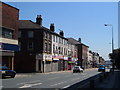
Wavertree Road, Edge Hill
This is the B5178, heading eastwards out of Liverpool, taken from near Image
Image: © Derek Harper
Taken: 17 Jul 2006
0.07 miles
4
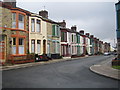
15-37 Marmaduke Street, Liverpool
Boarded up Victorian houses which, like those in the streets behind, have since been demolished, to be replaced by new housing. Crazy stuff.
Image: © Stephen Richards
Taken: 9 Jun 2013
0.11 miles
5
The Weighing Machine, Edge Hill
Another view of Image from the crossroads of Wavertree Road (left) with Image (right) and Overbury Street (left).
Image: © Derek Harper
Taken: 17 Jul 2006
0.11 miles
6
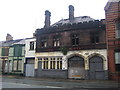
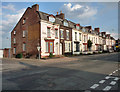
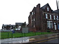
Liverpool: Durning Road former Fire Police Station
This interesting building at No. 63 Durning Road was sadly and ironically damaged by a fire in 2004. It was built in 1885 on the west side of Durning Road as a Fire Police Station. The word "Police" can still be picked out behind the buddleia between "Fire" and "Station". It is Grade II listed and is on the charity Save Britain's Heritage's Buildings at Risk Register. It has more recently been in use as a tyre dealers.
Image: © Nigel Cox
Taken: 16 Jun 2007
0.12 miles
7
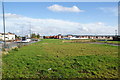
Site of cleared terraced housing by Edge Lane
Over to the right, new houses are being built.
Image: © Bill Boaden
Taken: 19 Oct 2013
0.12 miles
10
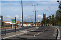
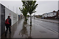
Edge Lane, Liverpool
Probably the most direct route into Liverpool for many people. In the background is St Cyprian's Church.
Image: © Bill Boaden
Taken: 19 Oct 2013
0.13 miles