IMAGES TAKEN NEAR TO
Cameron Street, LIVERPOOL, L7 0EN
Introduction
This page details the photographs taken nearby to Cameron Street, L7 0EN by members of the Geograph project.
The Geograph project started in 2005 with the aim of publishing, organising and preserving representative images for every square kilometre of Great Britain, Ireland and the Isle of Man.

There are currently over 7.5m images from over14,400 individuals and you can help contribute to the project by visiting https://www.geograph.org.uk
Image Map
Images are licensed for reuse under creativecommons.org/licenses/by-sa/2.0
Notes
- Clicking on the map will re-center to the selected point.
- The higher the marker number, the further away the image location is from the centre of the postcode.
Image Listing (36 Images Found)
Images are licensed for reuse under creativecommons.org/licenses/by-sa/2.0
Image
Details
Distance
1
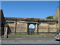
Deane Road Jewish Cemetery
In 1835, this site in the Kensington district was purchased as a formal burial ground for the Hebrew congregation who had become such an integral part of the city. A huge, ornate archway was built to serve as its entrance, made of brick and rendered in stucco and stone, in the Greek revival style. Sadly this is all that remains of the grand entrance today, the walls and railings now grade II listed to prevent further loss. There is a fascinating website with photos and information at the link below:-
http://www.deaneroadcemetery.com/index.html
Image: © Sue Adair
Taken: 10 Jun 2008
0.09 miles
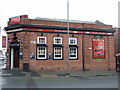
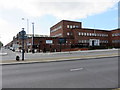
2
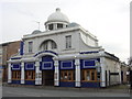
Converted Cinema, Kensington, Liverpool
Retaining the original facade it has been converted to a Wetherspoons bar.
Image: © Sue Adair
Taken: 31 Oct 2005
0.11 miles
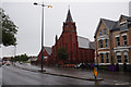
3
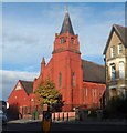
Former Christian Church: now Hindu Cultural Organisation
Image: © Anthony Parkes
Taken: 11 Oct 2014
0.13 miles
4
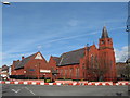
The Hindu Cultural Centre, Edge Lane
The Hindu Cultural Organisation was formed in the 1958 and in 1978 moved to their present location. They provide free community meals, advice on visas, employment, housing/accommodation and many other activities and festivals.
Image: © Sue Adair
Taken: 8 Mar 2007
0.13 miles
5
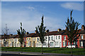
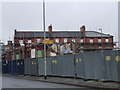
Terraced houses on Toft Street
Isolated as part of the Edge Lane clearance, but now colourfully maintained.
Image: © Bill Boaden
Taken: 19 Oct 2013
0.14 miles
7
Hindu Cultural Organisation
O Edge Road, Liverpool.
Image: © Ian S
Taken: 11 Jun 2019
0.14 miles
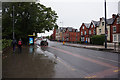
10
The Grange/Kensington Drill Hall, Liverpool
Looking across Edge Lane towards the former home of the 4th West Lancashire Howitzer Brigade, Royal Field Artillery (7th and 8th Howitzer Batteries). The drill hall itself faces Botanic Road, and its high roofs can be seen behind the more modern buildings. The name The Grange dates back to the old sandstone farmhouse that once stood on the site, and part of the building is now occupied by The Grange Vintage Furniture Centre.
Image: © John S Turner
Taken: 2 Sep 2014
0.17 miles