IMAGES TAKEN NEAR TO
Elm Vale, LIVERPOOL, L6 8NZ
Introduction
This page details the photographs taken nearby to Elm Vale, L6 8NZ by members of the Geograph project.
The Geograph project started in 2005 with the aim of publishing, organising and preserving representative images for every square kilometre of Great Britain, Ireland and the Isle of Man.

There are currently over 7.5m images from over14,400 individuals and you can help contribute to the project by visiting https://www.geograph.org.uk
Image Map
Images are licensed for reuse under creativecommons.org/licenses/by-sa/2.0
Notes
- Clicking on the map will re-center to the selected point.
- The higher the marker number, the further away the image location is from the centre of the postcode.
Image Listing (10 Images Found)
Images are licensed for reuse under creativecommons.org/licenses/by-sa/2.0
Image
Details
Distance
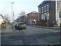
1
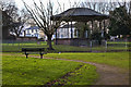
The bandstand at Newsham Park
The bandstand was erected 30 years after the park was officially opened in 1868 when the popularity of Sunday afternoon band concerts was at its peak.
Image: © Ian Greig
Taken: 2 Jan 2015
0.11 miles
6
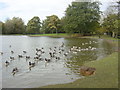
Canada Geese on Newsham Park Lake
1865 Liverpool Corporation commissioned the renowned landscape architect Edward Kemp to design a much-needed public park for the city. Newsham Park, with its bandstand, lakes and aviary was completed in 1868.
Image: © Sue Adair
Taken: 31 Oct 2005
0.24 miles
7
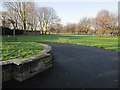
A former fountain in Newsham Park
A view of Newsham Park with part of a former ornamental fountain on the left. There is an Ordnance Survey bench mark under the lip of the coping stone on the left - see Image
Image: © John S Turner
Taken: 28 Jan 2012
0.24 miles
8
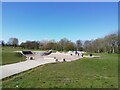
Newsham Park Skatepark
Newsham Park Skatepark is a large concrete skatepark opened in November 2015. The skatepark is essentially separated into two sections, a large bowl and a back and forth plaza.
Image: © Sue Adair
Taken: 15 Apr 2021
0.24 miles
9
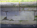
Bench mark on a former fountain in Newsham Park
This bench mark, which is full of moss, faces east from under the lip of the old stone fountain, and so is never exposed to any sunshine. The mark is recorded on the 1951 O.S. map. See also Image
Image: © John S Turner
Taken: 28 Jan 2012
0.24 miles
10
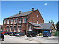
St Sebastian's School - (now L?Arche ) Lockerby Road
St Sebastian's School first opened in May 1909 with 131 pupils. The school moved to a new building in Holly Road in 1980 but the old school is still in use today by the L"Arche community.
"L’Arche Liverpool is Christian Community of 150 people in central Liverpool where people with and without learning disabilities live and work together.
It was a Dominican priest called Père Thomas Philippe who helped Jean Vanier 'begin something' with people with learning disabilities, about 40 years ago in France. Jean, originally an officer in the Royal Navy, had become an academic in Canada, but he felt increasingly called to this different life. He met two men called Raphael Simi and Philippe Seux who were living in a large institution near Paris - the only home they'd known for many years. Jean invited them to come and make a home with him. He knew he could not help everyone, but that by helping a few, together they might be a sign to others. L'Arche first arrived in the UK in 1974 with help from Jean's sister, Thérèse, a London doctor. The first community opened in Kent. There are now nine communities in the UK."
Information taken from the website below:
http://www.larcheliverpool.org/index.php
Image: © Sue Adair
Taken: 19 Jun 2008
0.25 miles